Unmanned Aerial Vehicles (UAVs) have become much more useful due to concurrent technological advancements. Individual tree detection is important to managing forests, but changing from traditional data collection to UAVs to collect this data is daunting due to the huge amount of information available.
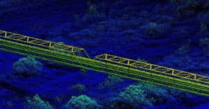
The team of international researchers wrote this article as a tutorial to help non-researchers understand the benefits of using UAVs to do research usually done using airplanes. They break down how to do Individual Tree Detection (ITD) using images and LiDAR maps from UAVs carrying Phoenix Scout LiDAR cameras, and also using open source software to process the data. The software created a canopy height model (CHM) and also performed ITD.
Because this approach is aimed at beginners to remote sensing (using drones to capture data), the methods are simplified and the tree areas studied are relatively easy to study due to relatively open canopies.
Doing this kind of work in a timely manner is important for understanding the forest’s response to climate change. Traditional study methods provide the data, but at a higher financial, time, and labor cost. Especially if there is a lot of forest to monitor. UAVs can provide the data at significant savings to all three costs.
The tutorial uses R studio software and the R programming language.
The size of the first area studied is 11.95 out of approximately 700 hectares of the E.O. Siecke State Forest, East Texas, which is managed by the Texas A&M Forest Service. This aerial imagery was gathered in August 2020 using a DJI Mavic Pro quadcopter, using the
Pix4Dcapture flight planning app.
The size of the second area studied is 23.04 hectares of the Ordway-Swisher Forest Dynamics Plot at the Ordway-Swisher Biological Station in Florida. The station is a long-term research facility by the University of Florida and it is also part of the Global Earth Observation Network
(ForestGEO) (https://forestgeo.si.edu/). The LiDAR data were collected in June 2019 with the
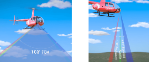
GatorEye Unmanned Flying Laboratory (http://www.gatoreye.org/). This system is composed of a DJI M 600 Pro hexacopter with a Phoenix Scout Ultra core, which has a STIM300 inertial measurement unit (IMU) coupled with a differential GNSS antenna and integrates a Velodyne
Ultra Puck 32c, a 24 MP visual camera, and a Headwall Photonics Nano hyperspectral camera. The data were post-processed using the GatorEye multi-scale post-processing (GMSPP) workflow (v. 229 detailed at http://www.gatoreye.org/).
The tutorial covers the following:
Loading the data
Clipping the area of interest
Classifying ground points
Creating a DTM
Height normalization of the point cloud
Creating a CHM
“Smoothening” the CHM
Detecting the treetops
Assessing accuracy
The goal is to help lay people understand how UAVs can help researchers do their work. Reducing the costs and complexity of this kind of research by using a UAV with a Phoenix Scout Ultra LiDAR camera, instead of an airplane-mounted option, makes this type of research more accessible to other researchers.
