An international team of scientists from the University of Florida (USA), University of São
Paulo (Brazil), Florida A&M University (USA), USDA Forest Service (USA), Federal University of
Paraná (Brazil), University of Maryland (USA), and Bangor University (UK) worked together to
use the University of Florida’s GatorEye unmanned aerial vehicle (UAV) LiDAR system to fight
climate change. The GatorEye system uses Phoenix LiDAR cameras and software to compare
and contrast tree crowns and forest structure over time.
When storms and hurricanes change the forest canopy structure, traditional LiDAR takes too
much time and logistical planning to quickly assess the damage. Phoenix UAV LiDAR can
autonomously and efficiently get high-resolution, quality data from relatively large areas
(hundreds to thousands of hectares) to help decision makers with post-storm recovery.
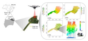
The team compared aircraft-borne LiDAR surveys of the Apalachicola National Forest, USA with
single-pass GatorEye UAV LiDAR surveys. They found the following:
● Digital Terrain Models (DTM) with less than 1 m differences between airborne and UAV
LiDAR, within a 145 degree field of view.
● Canopy height models (CHM) provided reliable information from the top layer of the
forest, allowing reliable treetop detection, though tree height underestimations occurred
at 175 m from the flightline.
● Crown segmentation was reliable only within a narrower field of view, from which the
shadowing effect made it unviable.
Because UAV LiDAR is limited by onboard battery capacity, this group is researching efficient
sampling methods using single-pass surveys that focus on samples of specific locations only.
Despite the limitations, UAV LiDAR systems cost less and are more flexible, enabling rapid
planning and response, as well as more frequent data collection and higher point density data.
Single-pass surveying has not been studied for airborne LiDAR, but using LiDAR for monitoring
forest health is well studied. Airborne LiDAR data is highly dependent on the flightline, which
determines pulse density and usually includes overlapping. Phoenix UAV LiDAR is more
efficient with a single pass, but closer to the objects being surveyed, mitigating the difference in
density. Scan angle makes a large difference, and further research is required to determine
accuracy based on scan angle.
This study included sample areas in the Apalachicola National Forest, public land in the sandhills of the Florida Panhandle that covers approximately 233,000 hectares.