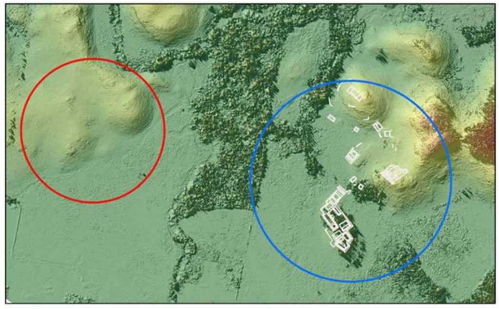
We conducted unmanned aerial vehicle lidar missions in the Maya Lowlands between June 2017 and June 2018 to develop appropriate methods, procedures, and standards for drone lidar surveys of ancient Maya settlements and landscapes. Three site locations were tested within upper Usumacinta River region using Phoenix Lidar Systems: Piedras Negras, Guatemala, was tested in 2017, and Budsilha and El Infiernito, both in Mexico, were tested in 2018. These sites represent a range of natural and cultural contexts, which make them ideal to evaluate the usefulness of the technology in the field. Results from standard digital elevation and surface models demonstrate the utility of deploying drone lidar in the Maya Lowlands and throughout Latin America. Drone survey can be used to target and efficiently document ancient landscapes and settlement. Such an approach is adaptive to fieldwork and is cost effective but still requires planning and thoughtful evaluation of samples. Future studies will test and evaluate the methods and techniques for filtering and processing these data.
Drone-Mounted Lidar Survey of Maya Settlement and Landscape
Fill Out the Form to Download the Resource
Table of Contents
Related Posts

The Best DJI M300 UAV LiDAR Solutions – RECON-XT & MiniRANGER-3
September 5, 2022If you are looking for a high-performance yet light weight solution, the RECON-XT and MiniRANGER-3 are both versatile and affordable…
Ranger-UAV | A7R4-Lite
March 29, 2024Speed: 6 m/sPoint Density: 200 points/m² per flight lineAGL: 120 mAcquisition time: 10 minutes
Using high-density UAV-Lidar for deriving tree height of Araucaria Angustifolia in an Urban Atlantic Rain Forest
August 1, 2021Urban forest remnants contribute to climate change mitigation by reducing the amount of carbon dioxide in urban areas. Hence, understanding…
