Search
Resource Type
Industry
Products
Sort
Exclusive Promotional Offer! Scout Sale 2021. OUR LOWEST PRICES…EVER.
Ends June 15th, 2021
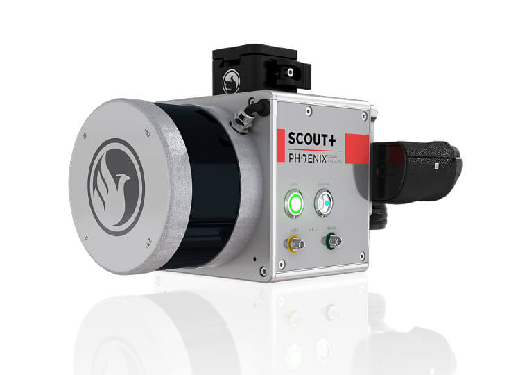
Promotion 1: Scout – 16 Basic Payload Package – Includes: Phoenix Lidar Systems Scout – 16 Payload System; Scout Accessory Kit; Sony A6k Lite 15mm Camera; Camera Kit; IMU – 25; Lidar Acquisition Training
Promotion 2: Scout – 16 Aerial Mapping Package – Includes: Phoenix Lidar Systems Scout – 16 Payload System; Scout Accessory Kit; Sony A6k Lite 15mm Camera; Camera Kit; IMU – 25; Phoenix Lidar Systems Spatial Explorer Pro v. 6 Software; NavLab Software; DJI Matrice 600 Pro Ready-to-Fly Package; Lidar Acquisition Training; Software Training; Pilot Training
Promotion 3: Scout Ultra Basic Payload Package – Includes: Phoenix Lidar Systems Scout – 16 Payload System; Scout Accessory Kit; Sony A6k Lite 15mm Camera; Camera Kit; IMU – 25; Lidar Acquisition Training
Promotion 4: Scout Ultra Aerial Mapping Package – Includes: Phoenix Lidar Systems Scout – 16 Payload System; Scout Accessory Kit; Sony A6k Lite 15mm Camera; Camera Kit; IMU – 25; Phoenix Lidar Systems Spatial Explorer Pro v. 6 Software; NavLab Software; DJI Matrice 600 Pro Ready-to-Fly Package; Lidar Acquisition Training; Software Training; Pilot Training
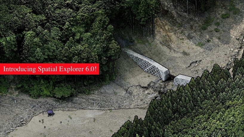
SpatialExplorer Pro 6.0 – 50% Off = Ends April 30th, 2021
SE Pro 6.0 is the evolution of a platform designed to carry you through every stage of collection and processing. Packed with production-oriented features, SpatialExplorer Pro 6.0 allows you to monitor & control the system during data collection, automatically boresight your data, apply cutting-edge algorithms to optimize the trajectory, apply control corrections, and generate the deliverables you commonly deliver to your client. Version 6.0 has several optimizations that are focused on creating the best deliverables in the shortest timeframe. Check out all the features here!
Sign up for SpatialExplorer 6.0 before April 30th and receive a 1-year license for 50% off! Click the button below to get in touch with our sales team today!
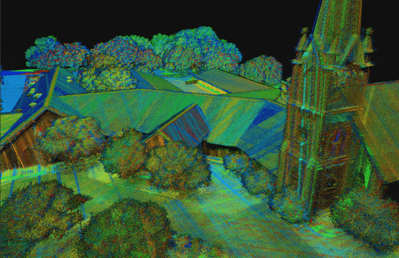
Join Phoenix LiDAR Systems in their March 2021 webinar as they unveil their latest software releases, Spatial Explorer 6 and 6 Pro. Hosted by Terry Owens from the sales team and Conrad Conterno, head of post-processing, this informative session provides an in-depth overview of Phoenix LiDAR’s innovative multi-platform solutions and industry-leading advancements.
Learn about the comprehensive features of Spatial Explorer 6 and 6 Pro, from basic sensor control and data export to advanced calibration and post-processing tools. Discover how the new A-to-Z workflow integrates NavLab for seamless trajectory processing, and explore enhanced features like automated bore sighting, LiDARSnap, and CameraSnap for optimized data accuracy.
The webinar also includes a detailed Q&A session, addressing compatibility, geoid applications, and software comparisons, with insights from CTO Ben Adler. Don’t miss this opportunity to see how Spatial Explorer 6 Pro can streamline your LiDAR data processing and deliver superior results.

Founded in 2014, Nordic Unmanned is largely recognized as one of Europe’s fastest growing experts in achieving reliable data solutions in the field of #digitalization. As an industry leader and the only listed drone operator in Europe, Nordic Unmanned retains strategic global partnerships with solution providers in the industries of #logistics, #energy, and #defense, and is continually helping to shape the regulatory standards for unmanned aircraft across Europe.
Both PLS and Nordic Unmanned recognize the growing interest in high-quality, built-for-purpose, turn-key solutions in the rapidly evolving unmanned aerial market.
Speaking about the new partnership, Justin Wyatt, Vice President of Sales stated “We are extremely pleased to sign this partnership agreement with Nordic Unmanned, a company with whom we have a shared vision to provide industry-leading products and services to the fast-evolving industry within Europe. As two companies committed to innovation and creating customer-focused solutions, we are excited about the many advantages such a partnership can offer to the market”. #uav #uas #lidar #dronesurvey #photogrammetry #innovations #3dmeasurement
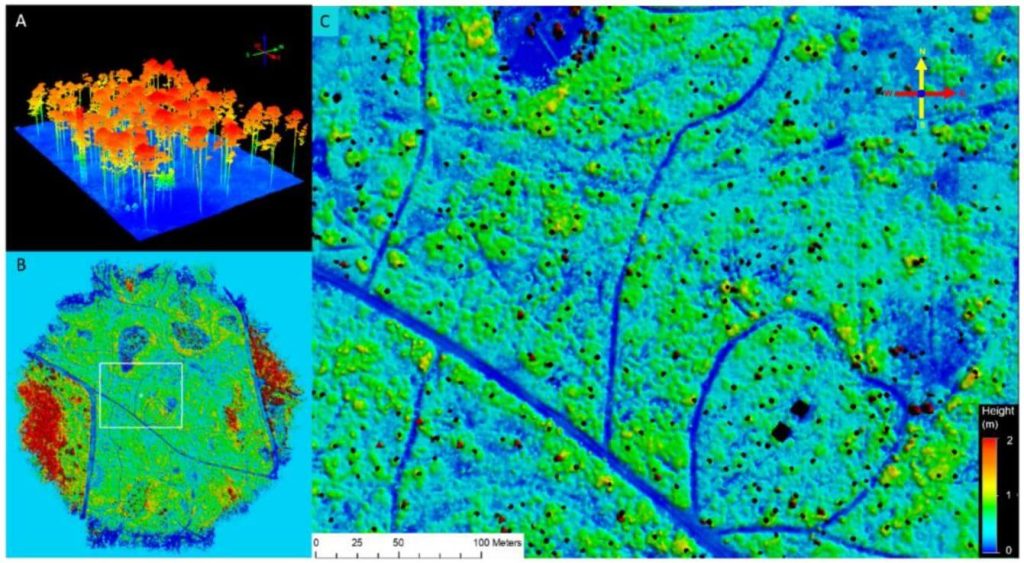
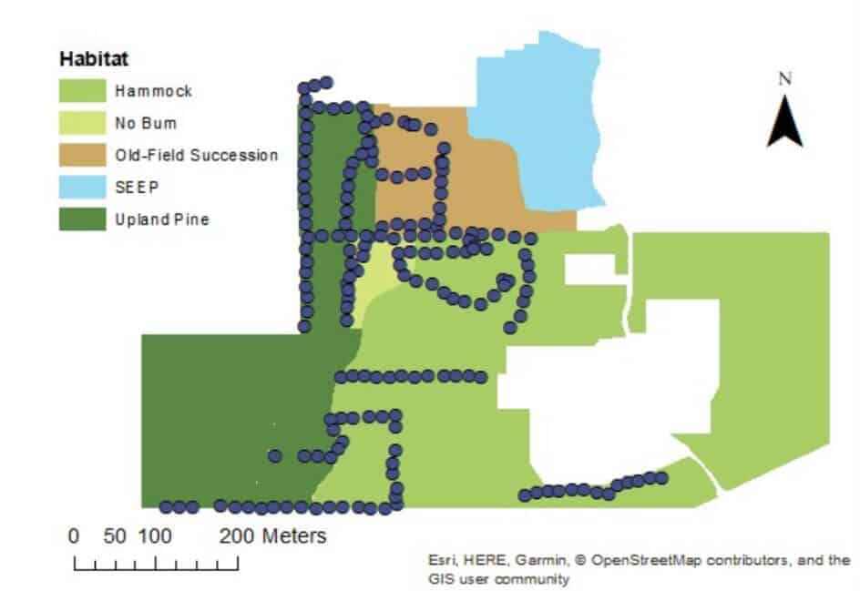
This whitepaper explores the application of high-density UAV-borne LiDAR technology for monitoring understory dynamics in the pine savannas of the southeastern United States, particularly in the context of prescribed fire management. Traditionally, understory characteristics such as height and biomass have been monitored through field sampling, but this study contrasts these conventional methods with advanced remote sensing techniques.
Utilizing the GatorEye UAV system, LiDAR data provided spatially explicit estimates of understory height and biomass before and after a prescribed fire. The results showed significant correlations between LiDAR-derived measurements and traditional field data, demonstrating the accuracy and efficiency of LiDAR technology.
Notably, LiDAR’s comprehensive spatial coverage revealed a smaller biomass reduction after the burn compared to in-situ measurements, highlighting the importance of capturing spatial variability. The findings underscore the potential of LiDAR as a powerful tool for land managers, offering enhanced spatial and temporal resolution in tracking understory biomass and its response to fire, ultimately supporting more effective ecosystem management practices.
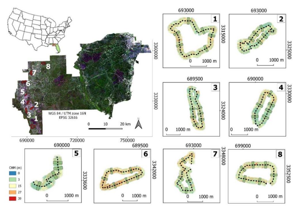
This whitepaper examines the efficiency and accuracy of UAV-borne LiDAR, specifically the GatorEye system, for high-resolution forest data acquisition, comparing it to traditional aircraft-borne LiDAR in the Apalachicola National Forest, USA. The study assesses the effectiveness of single-pass flight plans for generating digital terrain models (DTMs) and canopy height models (CHMs).
Results indicate that DTMs derived from UAV LiDAR showed less than 1 meter difference compared to aircraft-derived DTMs within a 145° field of view (FOV). CHMs provided reliable treetop detection, though tree height underestimations occurred at distances over 175 meters from the flight line. Crown segmentation was effective within a 60° FOV, but shadowing effects hindered its accuracy beyond this range.
The study identifies optimal quality thresholds for various LiDAR products, supporting the development of efficient, cost-effective UAV flight plans for forest monitoring. These findings highlight the potential of UAV-borne LiDAR for detailed, multi-temporal forest structure assessment, offering valuable insights for forest management and conservation strategies.
This whitepaper explores the effectiveness of UAV-borne LiDAR technology for detecting small trails (less than 2.5 meters wide) in mixed forest canopy ecosystems. Accurate trail mapping is crucial for forest management, monitoring, and conservation, yet current sensor technology for sub-canopy detection is still evolving.
The study compares trail detectability using high-definition surface models from UAV LiDAR data and high-resolution satellite imagery from Google Earth. Through participatory mapping, respondents with limited geospatial experience identified trails on both map types. Results showed higher detection rates on the LiDAR-derived map compared to the satellite imagery. In satellite maps, trail detectability was positively correlated with wider trails and lower canopy cover, whereas LiDAR maps showed increased detectability with wider trails regardless of canopy cover.
This mixed-method approach, combining UAV-mounted LiDAR, satellite imagery, and participatory mapping, enhances the rapid detection of small trails under varying conditions, offering valuable insights for improving forest management and conservation efforts.
In this informative presentation by Kory Kellum from Phoenix LiDAR Systems, viewers will gain a comprehensive understanding of UAS LiDAR systems. Kory delves into the essential components of a LiDAR system, such as the LiDAR sensor, GNSS antenna, IMU, data storage, CPU, and optional camera, emphasizing the need for high-quality trajectories through post-processed kinematic (PPK) methods and bore site calibration.
He outlines the critical steps in processing UAS LiDAR data, from mission planning to classification, and categorizes LiDAR systems based on precision, accuracy, point density, and maximum range. Corey also compares multi-laser and single-laser sensors, discusses the selection of GNSS antennas and IMUs, and provides an overview of current LiDAR systems like the Ranger series, and Scout series. The presentation highlights the benefits of co-acquiring imagery and features examples of data outputs to illustrate system performance.
Concluding with a Q&A session, this video is a must-watch for those interested in selecting the right LiDAR system for their specific needs and budget.
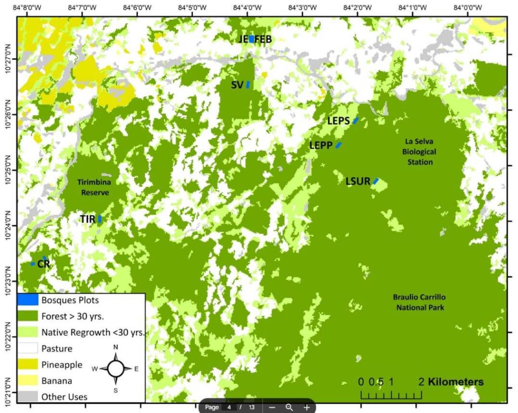
This whitepaper investigates the innovative application of the GatorEye drone-borne LiDAR system for monitoring tropical forest succession through detailed canopy structural attributes. These attributes include canopy height, spatial heterogeneity, gap fraction, leaf area density (LAD) vertical distribution, canopy Shannon index, leaf area index (LAI), and understory LAI.
Focusing on nine tropical forest stands in the Caribbean lowlands of northeastern Costa Rica, the study evaluates the relationship between these variables and aboveground biomass (AGB) stocks and species diversity. The analysis reveals that while canopy height and AGB do not show a clear pattern with forest age, gap fraction and spatial heterogeneity increase, and understory LAI decreases as forests age.
Notably, canopy height is strongly correlated with AGB. The study demonstrates that drone-LiDAR systems significantly enhance the characterization of heterogeneous mosaics created by successional forest patches in human-managed landscapes. This technology offers a valuable tool for improving forest recovery assessments and developing mechanistic carbon sequestration models, crucial for tracking progress within the UN Decade on Ecosystem Restoration.
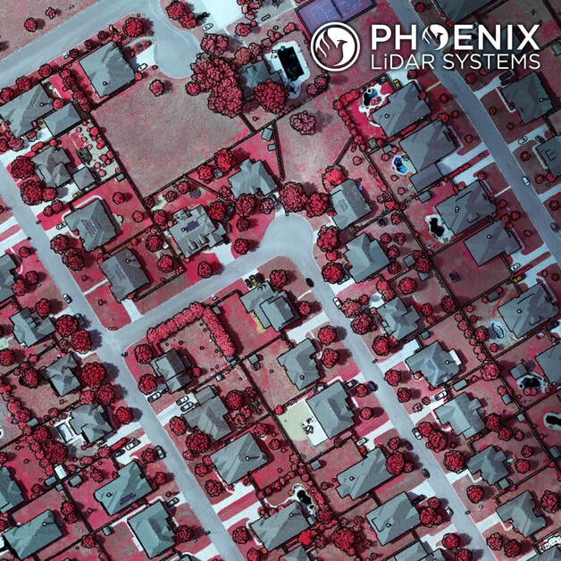
A few weeks ago we posted a video of a completed Ranger-XL ready for shipment. Here’s a peek at a recent dataset collected by that same Ranger-XL coupled with the 100MP Phase One 4-band Solution. This urban corridor was easily captured with a single pass, creating a stunning dataset with high Imagery and LiDAR resolution. Data specs: 80 Points Per Square Meter Average for LiDAR and 3cm GSD for imagery.
We are excited to announce the opening of our new headquarters based in Austin, Texas! Our new facility offers numerous benefits to advance our operations and meet our customers’ needs:
• More than double the size of our Los Angeles facility
• Spacious conference rooms to accommodate multiple concurrent customer training sessions
• Close proximity to field sites for pilot and acquisition training
• Accommodations for system testing and calibration
• 30 minutes from the Austin-Bergstrom International Airport
• Less than 10 minutes from the Domain, a trendy Austin shopping center and social hotspot
As of Friday, June 26, 2020, all of our Los Angeles operations will be permanently relocated to our new facility located at:
2113 Wells Branch Parkway
Building 1, Suite #4000
Austin, TX 78728
We will not be able to receive mail or other shipments at 10131 National Blvd, Los Angeles, CA 90034 after June 26th. Please let us know if you have any questions.
Sincerely,
The Phoenix LiDAR Team