Whitepaper
LiDAR remote sensing systems utilizing GNSS/INS are reliant on the integration of an accurate Inertial Measurement Unit (IMU) to achieve high-quality data. The IMU forms the core of the navigation system, which is used to estimate a trajectory. This
trajectory is then used for georeferencing (“fusing”) raw LiDAR range data into a point cloud. IMUs vary in terms of performance and price, so selecting the right IMU for a given LiDAR application is an important step.
IMU hardware collects data from gyroscopes and accelerometers. Gyroscopes, which are used to measure rates of rotation along 3 axes (roll, pitch, and yaw), have inherent measurement imperfections. When a gyroscope is stationary and not rotating, output
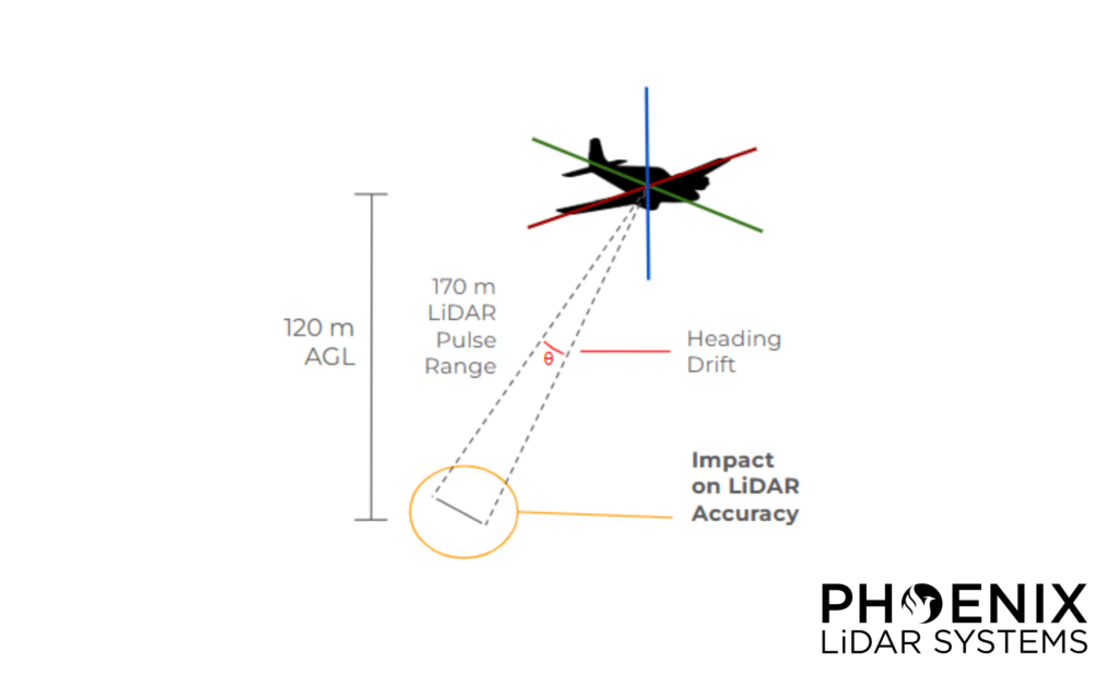
measurements, which should be constant due to the lack of rotation, will in fact change, or drift, over time. It’s important to consider that an IMU may drift along certain axes, even when not completely stationary. For example, traveling with a constant heading means that the gyroscope associated with measuring heading is nearly at rest and subject to drift. Drift along the heading axis is typically more impactful than the drift observed along the pitch and roll axes, as “A good portion of the pitch (attitude) and roll axis gyroscope drift can be removed within an IMU through the use of accelerometer feedback to monitor position relative to gravity” (Analog Devices, 2017).
Heading drift is most pronounced when a vehicle travels in a relatively straight path for a prolonged period of time, as heading estimates degrade in accuracy due to an accumulation of gyroscope noise. This is particularly problematic with aerial LiDAR
data acquisition, as single-grid type and corridor acquisitions must take into account how long the IMU can travel in a straight path without accumulating too much drift. To mitigate this, operators will typically limit their flight line lengths accordingly or
perform dynamic maneuvers in the middle of long flight lines.
Download the whitepaper to learn more.
View our other whitepapers in our resource library.
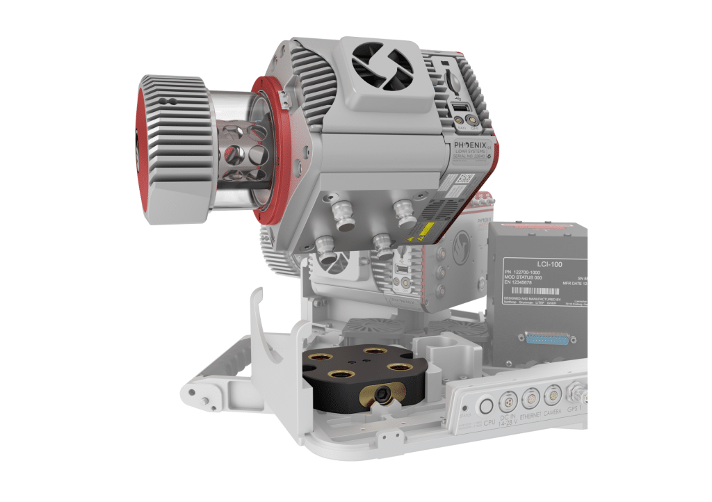
Modularity is a key feature of the RANGER-FLEX laser mapping product line.
These systems can be quickly reconfigured, with sensors added and/or removed, to allow for optimized utilization on a variety of vehicle types. Modularity also presents a challenge: How can a system calibration, which is a cornerstone of data accuracy, be preserved if laser scanners and cameras are routinely separated from each other and from the navigation system? The RANGER-FLEX has been engineered to specifically address this, and a series of datasets were collected to test the stability of its calibration.
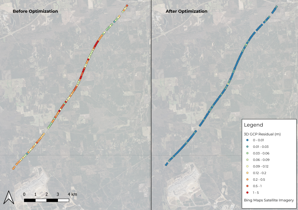
Phoenix LiDAR’s SpatialExplorer’s LiDARSnap strip alignment tool was tested using a challenging mobile LiDAR dataset collected along a rural state road, Natchez Trace Parkway, near Mathiston, Mississippi. Approximately 17.5 km of the parkway was mapped using the RANGER Flex dual-head mobile LiDAR mapping system.
Of the total mapped area, nearly 85% was covered by a dense tree canopy, which posed a significant accuracy challenge due to the limited availability of GNSS signals. LiDARSnap was utilized not only to calibrate the relative accuracy of the two passes but also to georeference the scan in relation to leveled control.
This paper discusses the processing workflow, results, and capabilities of LiDARSnap in challenging, GNSS-denied environments.
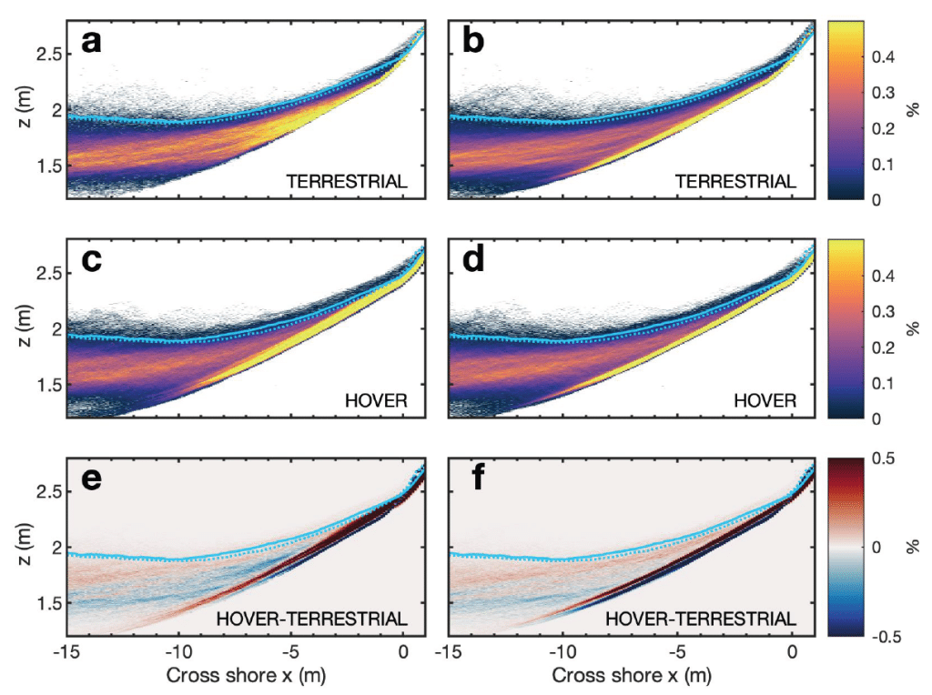
In this whitepaper, we explore the innovative application of a hovering drone-mounted LiDAR system paired with a survey-grade satellite and inertial positioning system to measure wave transformation and runup in the surf zone. Unlike traditional methods, the multi-rotor small uncrewed aircraft system (sUAS) offers unobstructed measurements by hovering above the surf zone at a 20-meter elevation, scanning a 150-meter-wide cross-shore transect.
This approach allows rapid and precise data collection in remote locations where terrestrial scanning is challenging. Our study demonstrates that hovering drone-mounted LiDAR provides measurement accuracy almost equivalent to a stationary truck-mounted terrestrial LiDAR. By conducting observations in various surf conditions and validating with traditional land-based surveys and pressure sensors, we achieved a stable back beach topography estimate.
We also calculated statistical wave properties, runup values, and bathymetry inversions using a simple nonlinear correction to wave crest phase speed. This method shows the potential of drone-based LiDAR for accurate nearshore process observations, enabling data collection in previously inaccessible sites and providing valuable validation for coastal models.
This whitepaper delves into the innovative use of high-density LiDAR data and Quantitative Structure Modelling (QSM) to estimate individual tree attributes, traditionally predicted by field-derived allometric models. Leveraging LiDAR data collected by Unmanned Aerial Vehicles (UAVs), we evaluated the accuracy of QSM in determining key tree metrics such as diameter at breast height (dbh), tree height, volume, and aboveground biomass components (stem, branch, and total).
Our study compares two QSM approaches: integrating QSM-derived dbh and height into field-based equations for volume estimation, and deriving tree volume directly from QSM. Despite a slight overestimation tendency, the models demonstrated satisfactory performance, highlighting QSM’s potential to provide detailed and extensive tree attribute estimates.
This method offers a promising alternative for forest management decision-making, especially in analyzing tree architecture and biomass. The findings underscore the value of UAV-LiDAR and QSM in enhancing the precision and scope of forest attribute assessments.
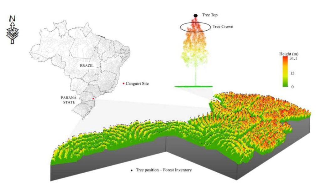
This whitepaper presents a novel approach to forest inventory within integrated crop-livestock-forest systems using high-density UAV-LiDAR point clouds. Focusing on Eucalyptus benthamii seed forest plantations, we utilized the GatorEye UAV-LiDAR system to compare two forest inventory methods: Sampling Forest Inventory (SFI) with various plot arrangements and Individual Tree Detection (ITD).
By analyzing a point cloud with over 1400 points per square meter, we assessed basal area and volume estimates using both field and LiDAR-measured heights. We compared the number of trees, basal area, and volume per hectare across different scenarios, using statistical analysis to evaluate accuracy and equivalence. Our results show that the SFI approach with a 2300 m² area provides estimates comparable to the ITD method, with minimal error and improved processing efficiency.
This study offers valuable insights for selecting optimal plot sizes in forest inventories, enhancing precision in integrated crop-livestock-forest systems.
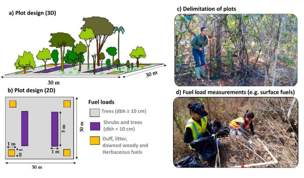
This whitepaper explores a groundbreaking framework for quantifying fuel load in fire-prone regions, focusing on the Brazilian tropical savanna (Cerrado biome), using NASA’s GEDI full-waveform spaceborne LiDAR sensor. Understanding fuel load is crucial for integrated fire management, preserving carbon stock, biodiversity, and ecosystem functioning, and assessing global climate regulation. Traditional remote sensing methods lack the capability to measure vertical vegetation structure accurately.
Our study leverages UAV-collected LiDAR data to simulate GEDI full-waveforms, from which we derive vegetation structure metrics. These metrics are then correlated with field-measured fuel load components using Random Forest models. The resulting models, which predict woody and total fuel loads with high accuracy (R² = 0.88 and 0.71, respectively), provide reliable estimates even for lower strata components.
This innovative approach allows for the creation of fuel load maps for the entire Cerrado and can be extended to other fire-prone regions, enhancing fire management and carbon monitoring efforts. This research showcases the potential of spaceborne LiDAR to revolutionize environmental management and climate initiatives in tropical savannas and beyond.
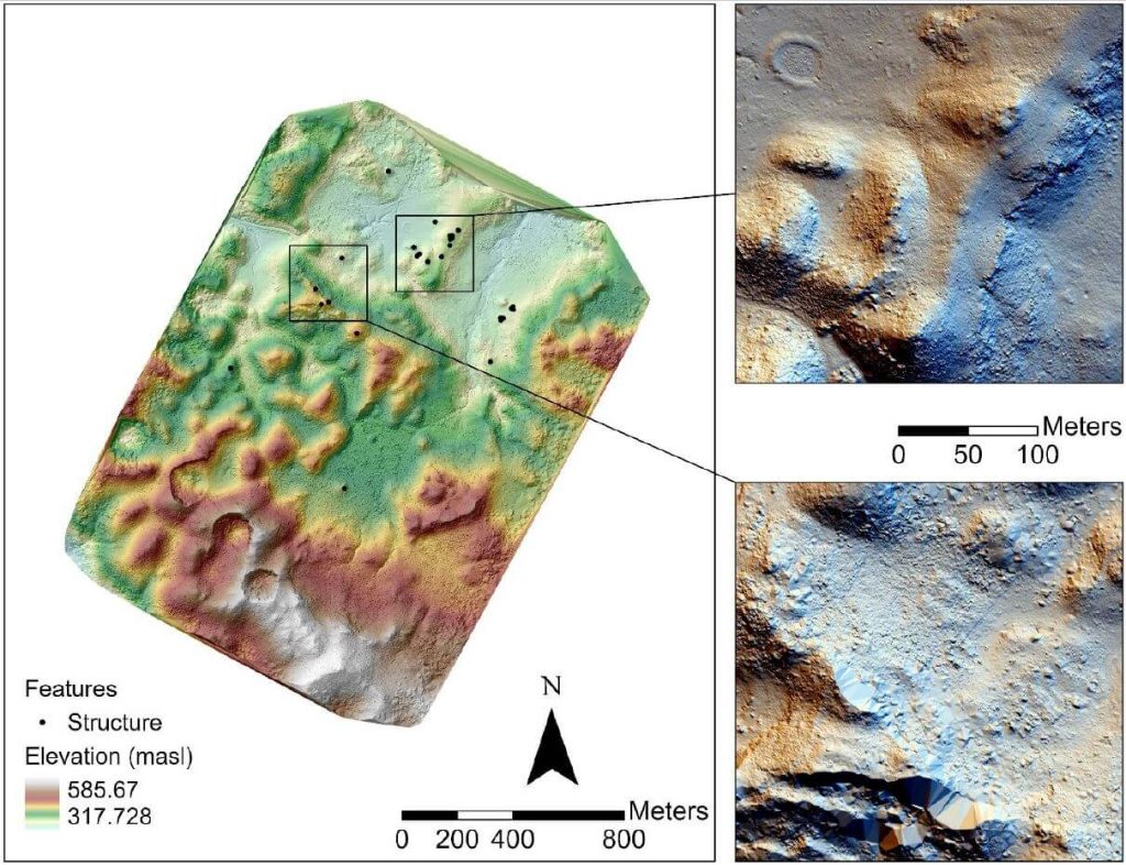
In recent years, airborne laser scanning has revolutionized the documentation of historic cultural landscapes, extending its applications from natural landscapes to built environments. The integration of unoccupied aerial vehicles (UAVs) with LiDAR systems is a transformative advancement, providing complementary data for precise mapping of targeted areas.
This whitepaper presents the findings from a 2019 study in the Maya Lowlands of Chiapas, Mexico, utilizing UAV LiDAR to capture and analyze data from six archaeologically significant areas. These areas, characterized by diverse environments, land cover, and archaeological features, were studied for their pre-Hispanic settlements and agrarian landscapes. The results confirm the immense potential of UAV LiDAR systems for high-precision archaeological mapping and underscore the importance of multidisciplinary collaboration.
The high-precision data acquired is invaluable for mapping archaeological features and understanding long-term land use and landscape changes in archaeological contexts.
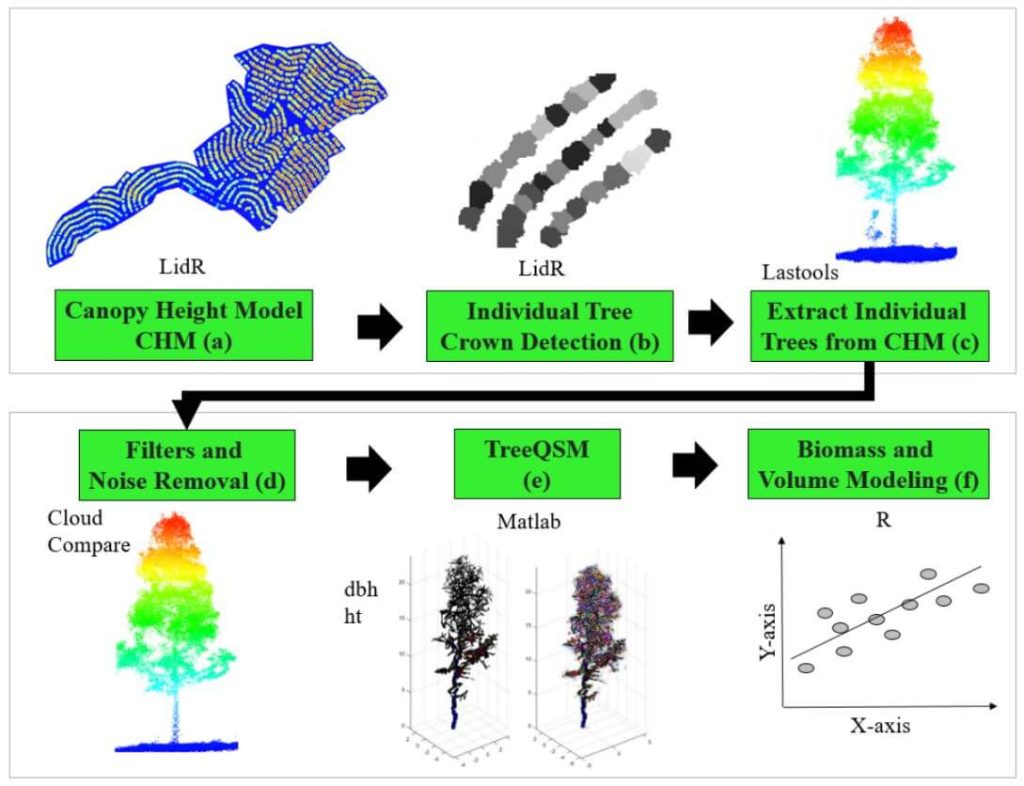
The proliferation of unmanned aerial vehicles (UAVs) over the past decade has been driven by advancements in structure-from-motion (SfM), machine learning, and robotics. A crucial application in forestry is individual tree detection (ITD), essential for calculating forest attributes like stem volume, forest uniformity, and biomass estimation.
This whitepaper addresses the challenges users face in adopting UAVs and algorithms for specific projects by providing a detailed tutorial for performing ITD. It covers the use of low-cost UAV-derived imagery and UAV-based high-density LiDAR, utilizing open-source R packages to develop a canopy height model (CHM) and implement the local maxima (LM) algorithm for ITD.
Accuracy assessments are derived through manual visual interpretation and field-data validation. Targeted at beginners in remote sensing, this guide employs a simple methodology and uses study plots with relatively open canopies. Supplementary materials include R codes and sample plot data to facilitate practical application.