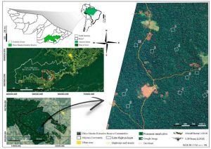
This whitepaper explores the effectiveness of UAV-borne LiDAR technology for detecting small trails (less than 2.5 meters wide) in mixed forest canopy ecosystems. Accurate trail mapping is crucial for forest management, monitoring, and conservation, yet current sensor technology for sub-canopy detection is still evolving.
The study compares trail detectability using high-definition surface models from UAV LiDAR data and high-resolution satellite imagery from Google Earth. Through participatory mapping, respondents with limited geospatial experience identified trails on both map types. Results showed higher detection rates on the LiDAR-derived map compared to the satellite imagery. In satellite maps, trail detectability was positively correlated with wider trails and lower canopy cover, whereas LiDAR maps showed increased detectability with wider trails regardless of canopy cover.
This mixed-method approach, combining UAV-mounted LiDAR, satellite imagery, and participatory mapping, enhances the rapid detection of small trails under varying conditions, offering valuable insights for improving forest management and conservation efforts.