Skip to footer
323-577-3366
Info@PhoenixLiDAR.com
Hardware
RANGER SERIES
HydroRANGER
RANGER-XL
RANGER-U160
RANGER-U120
MiniRANGER-3 LITE
RANGER-UAV FLEX
RANGER-UAV LITE
RANGER-LR LITE
RECON | SCOUT | PIONEER | HALO
RECON XT
SCOUT M2X
PIONEER 360
HALO H
HALO V
ULTRAPOD
RFM2
Featured
New Solutions
HydroRANGER
The ultimate shore-monitoring system
Learn More
DUAL MOBILE SYSTEM RFM2
A powerful mobile mapping system
Learn More
RECON-XTA
Designed specificly for the Freefly ASTRO
Learn More
Software
Save Time & Grow Your Business
A Complete LiDAR Software Suite from Phoenix LiDAR Systems
Learn More
Flight Planner
Optimize flight patterns, configure sensors, and fly
Learn More
Spatial Pro
Robust calibration, analytical and reporting tools
Learn More
LiDARMill
Automates your post-processing workflow
Learn More
Accessories
Resources
Resource Library
Dive into Our Resource Library
Industries
Products
Articles
Case Studies
Sample Data
Videos
Webinars
Whitepapers
Learn More
Sample Data
Explore Actual Data for a Range of Phoenix LiDAR Configurations
Learn More
Company
Overview
Phoenix LiDAR Systems was established in 2013 as Phoenix Aerial Systems with the goal of combining LiDAR scanning and UAV technologies.
Learn More
Careers
We’re growing! If you’re the right candidate, we’d love to meet you.
Learn More
Events
Discover the latest updates, insights, and innovations waiting for you.
Coming Soon
Contact
Contact Us
General Inquiries | Interested in Becoming a Distributor? | Need Support?
REACH OUT
Support
Help at every step along the way. Need to speak with a support technician now?
GET SUPPORT
Request a Quote
Discover the latest updates, insights, and innovations waiting for you.
CONTACT SALES
Feature Request & Feedback
Have an idea for a new feature or feedback on how we can do better? Drop us a note!
SEND FEEDBACK
Hardware
Overview
Software
SpatialExplorer
FlightPlanner
Spatial Pro
LiDARMill
Accessories
Resource Library
Company
Overview
Contact Us
My Account
Hardware
Overview
Software
SpatialExplorer
FlightPlanner
Spatial Pro
LiDARMill
Accessories
Resource Library
Company
Overview
Contact Us
My Account
Log In
Login to Phoenix LiDar System
Remember Me
Login
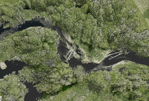
RANGER-LR | Dense Vegetation River Corridor
Environmental Engineering
Forestry
Industry
Product
Ranger-LR
ResourceType
Sample Data
Point Density:
320 points per m^2
Height:
80 m AGL
Speed:
8 m/s
Data Acquisition Time:
7 minutes
Fill Out the Form to Download the Resource
Download
First Name
Last Name
Company Name
Email
Submit
Resource Library Form - Test
First Name
Last Name
Company Name
Email
View Resource!
Table of Contents
Related Posts
LiDAR for Surveying & Engineering Applications
October 8, 2021
This is a panel discussion featuring two Surveying and Engineering Design service providers: EHRA and Wood Rodgers. We will discuss…
Environmental & Technical Challenges in Drone LiDAR
November 22, 2023
LiDAR technology, a groundbreaking innovation in the realm of surveying and remote sensing, has been a game-changer for many industries.…
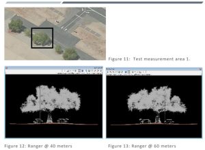
Dewberry – Airfield Obstruction Survey – Calibration Test Reporting
December 22, 2017
Under task order G17PD01249: Alaska Critical Infrastructure UAV Airfield Obstruction Survey the Dewberry team was tasked to perform a test…