Scout
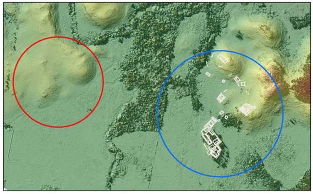
We conducted unmanned aerial vehicle lidar missions in the Maya Lowlands between June 2017 and June 2018 to develop appropriate methods, procedures, and standards for drone lidar surveys of ancient Maya settlements and landscapes. Three site locations were tested within upper Usumacinta River region using Phoenix Lidar Systems: Piedras Negras, Guatemala, was tested in 2017, and Budsilha and El Infiernito, both in Mexico, were tested in 2018. These sites represent a range of natural and cultural contexts, which make them ideal to evaluate the usefulness of the technology in the field. Results from standard digital elevation and surface models demonstrate the utility of deploying drone lidar in the Maya Lowlands and throughout Latin America. Drone survey can be used to target and efficiently document ancient landscapes and settlement. Such an approach is adaptive to fieldwork and is cost effective but still requires planning and thoughtful evaluation of samples. Future studies will test and evaluate the methods and techniques for filtering and processing these data.
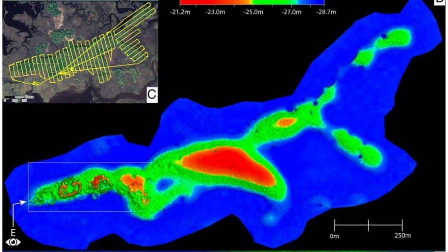
Drone-mounted, high-resolution light detection and ranging reveals the architectural details of an ancient settlement on the Gulf Coast of Florida without parallel in the Southeastern United States. The Raleigh Island shell-ring complex (8LV293) of ca. 900 to 1200 CE consists of at least 37 residential spaces enclosed by ridges of oyster shell up to 4 m tall. Test excavations in 10 of these residential spaces yielded abundant evidence for the production of beads from the shells of marine gastropods. Beads and other objects made from gulf coastal shell were integral to the political economies of second-millennium CE chiefdoms across eastern North America. At places as distant from the coast as the lower Midwest, marine gastropods were imported in raw form and converted into beads and other objects by craftspeople at the behest of chiefs. Bead making at Raleigh Island is exceptional not only for its level of production at the supply end of regional demand but also for being outside the purview of chiefly control. Here we introduce the newly discovered above-ground architecture of Raleigh Island and outline its analytical value for investigating the organization of shell bead production in the context of ancient political economies. The details of shell-ring architecture achieved with drone-mounted LiDAR make it possible to compare the bead making of persons distributed across residential spaces with unprecedented resolution.
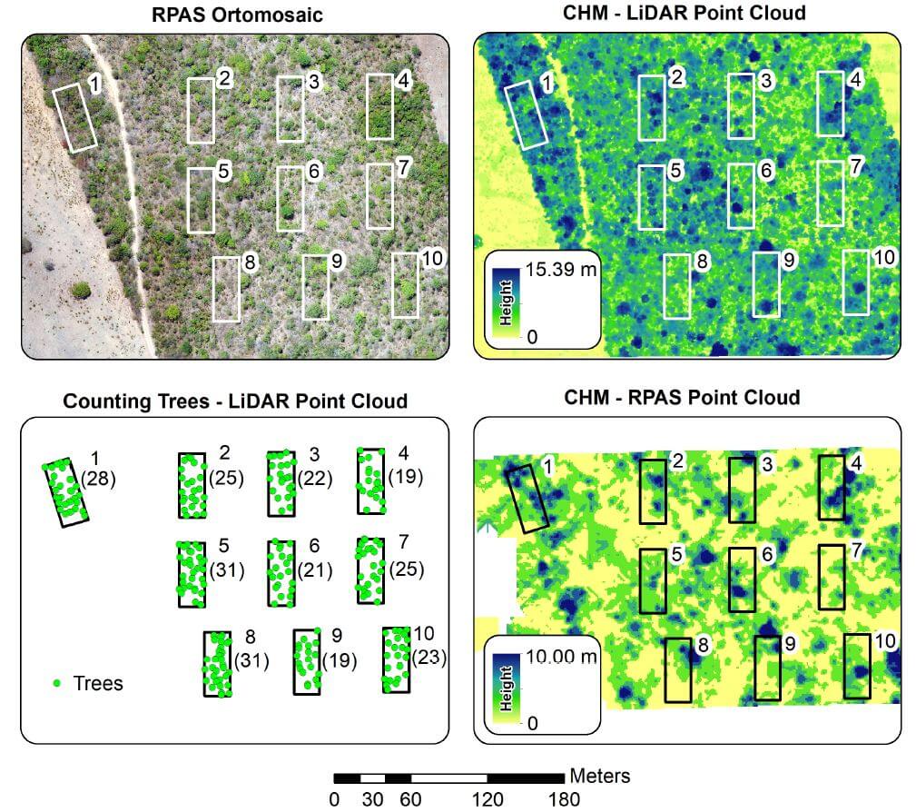
The Cerrado, the most biologically diverse savanna in the world, is threatened by anthropogenic activities, and requires development of effective environmental policies spanning local to global scales. Remotely Piloted Aircraft Systems (RPAS) can dramatically reduce the costs and time of surveys and evaluation of these regions. The objective of this article is to demonstrate the potential of visual (RGB) and Light Detection and Ranging (LIDAR) sensors on RPAS for physical characterization of landscapes in the Cerrado biome. Analyses on vegetation structure were performed, with the number of trees automatically counted. The average height of the trees obtained with the RGB sensor was significantly lower than the obtained by LIDAR, demonstrating the limitation of Structure from Motion data in representing the landscape with denser vegetation. Automatic counting of trees with LIDAR data were equal to 1825 on the whole study area, and 245 inside the ecological study area parcels.
Objective
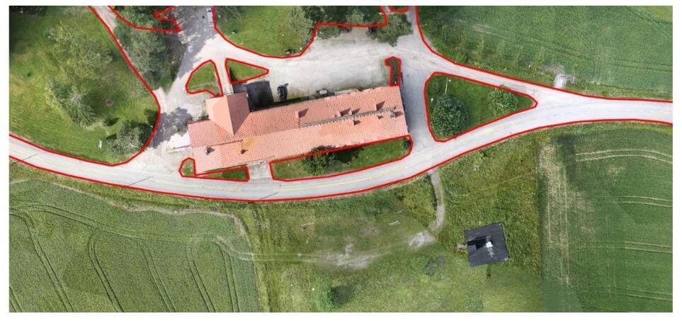
The objectives of the test campaign were:
– evaluating the accuracy of point clouds from Phoenix Aerial Systems in a realistic survey mission scenario
– testing the performance of Terrasolid software running on top of MicroStation CONNECT Edition, for calibration and further improvement of the data
The data sets were acquired with a Camflight FX8HL UAS platform and pre-processed to a trajectory file and to a point cloud file with Phoenix LiDAR Systems software. [register below to download full whitepaper]