
The Purpose of LiDAR
LiDAR (Light Detection and Ranging) is an advanced tool used for quickly, accurately, and densely measuring 3D features from the surrounding environment. As a form of remote sensing, LiDAR employs sensors to gather data on topography, vegetation, and other features across large areas, eliminating the need for physical measurements.
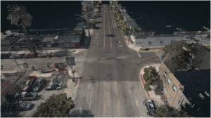
LiDAR sensors can capture hundreds of thousands of measurements per second, represented as a point cloud. This point cloud is crucial for various analytical processes, including distance measurements, volume computations, and 3D modeling.
How Does LiDAR Work?
LiDAR measures distance by emitting laser pulses and recording the time it takes for each pulse to travel to an object and reflect back to the sensor. Given the known speed of light, distance is calculated using the formula: distance = speed x time. Positioning and orientation sensors within the LiDAR system then convert these distance measurements into elevation data.
Position measurements are typically recorded once per second, while orientation measurements are taken between 125 and 400 times per second. These sensors are essential for accurately calculating the location and timing of each point collected by the LiDAR system.
In essence, a LiDAR system is an active remote sensing technology that emits laser pulses, captures the returned signals, and calculates the system’s position and orientation. This process produces a geospatially accurate 3D point cloud depicting the environment.
How Can LiDAR Measure the Ground Through Trees?
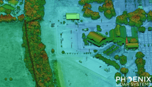
LiDAR operates by emitting laser pulses composed of light energy in the form of photon bundles. As these photons travel towards the ground, they encounter various objects such as buildings, trees, and vegetation. Some photons reflect off branches and return immediately to the sensor, while others pass through gaps in the foliage, striking lower branches or the ground before reflecting back.
This process, known as multiple returns, allows LiDAR to capture multiple reflections from a single pulse of light. The power of the laser and other factors determine the number of returns a LiDAR system can record. At Phoenix LiDAR Systems, some systems can record up to 15 returns, providing a true 3D representation of both vegetation and ground data.
Phoenix LiDAR Systems offers a range of high-performance LiDAR solutions capable of capturing detailed, accurate 3D data for a variety of applications.