The Rise of LiDAR in Geomatics LiDAR, or Light Detection and Ranging, has seen a surge in its application within the geomatics sector. Its ability to capture detailed and accurate data makes it an invaluable tool for professionals seeking to analyze department of transportation survey and engineering projects. As the demand for high-quality data grows, the need to understand the strengths and weaknesses of available LiDAR sensors becomes paramount.

DOT Drone LiDAR Accuracy Research
Fill Out the Form to Download the Resource
Table of Contents
Related Posts

The Most Powerful and Easy To Use LiDAR Software
October 24, 2022LiDAR processing can be complicated, expensive and slow. But there is a great solution from Phoenix LiDAR Systems - LiDARMill.…
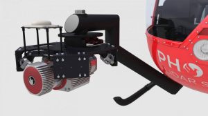
Multi-Vehicle Payload Flexibility
October 8, 2021Join us for a discussion about how a single LiDAR Payload can suit many needs by being vehicle flexible. During…
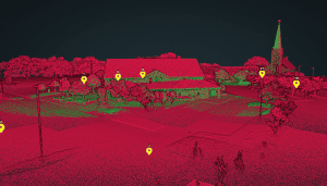
RECON-XT SLAM | Building Mapping inside and out
March 29, 2024Speed: Walking pace for SLAM. 6 m/s UAV flightPoint density: thousands of points/m²AGL: 80 during UAV flightAcquisition time: ~2 hours
