Customize Consent Preferences

We use cookies to help you navigate efficiently and perform certain functions. You will find detailed information about all cookies under each consent category below.

The cookies that are categorized as "Necessary" are stored on your browser as they are essential for enabling the basic functionalities of the site. ... 

Always Active

Necessary cookies are required to enable the basic features of this site, such as providing secure log-in or adjusting your consent preferences. These cookies do not store any personally identifiable data.

No cookies to display.

Functional cookies help perform certain functionalities like sharing the content of the website on social media platforms, collecting feedback, and other third-party features.

No cookies to display.

Analytical cookies are used to understand how visitors interact with the website. These cookies help provide information on metrics such as the number of visitors, bounce rate, traffic source, etc.

No cookies to display.

Performance cookies are used to understand and analyze the key performance indexes of the website which helps in delivering a better user experience for the visitors.

No cookies to display.

Advertisement cookies are used to provide visitors with customized advertisements based on the pages you visited previously and to analyze the effectiveness of the ad campaigns.

No cookies to display.

Log In
Login to Phoenix LiDar System
Drone LiDAR Video Thumbnail

Environmental & Technical Challenges in Drone LiDAR

Reading time: 1 minutes
Date: November 20, 2023

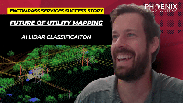
Discover the transformative power of drone-based LiDAR technology in this insightful video featuring industry experts James Kessner and Aaron Handl from Encompass Services. Explore how drones, integrated with LiDAR, are revolutionizing surveying and remote sensing by offering precise, cost-effective data collection alternatives to traditional methods. 

The video delves into the environmental and technical challenges of drone LiDAR, including weather impacts and accessibility, and discusses solutions such as Trimble Business Center and LiDARMill for efficient data processing and analysis.

Learn about the importance of point cloud data classification, wire detection through dense vegetation, and the role of advanced tools like the Recon MiniRanger sensor and AI-powered software in enhancing data accuracy. 

This video also highlights the applications of LiDAR data in generating imagery and orthomosaics for subsurface utility engineering projects, providing critical insights for utility companies and engineers.

Join Kessner and Handl as they navigate the complexities of drone-based LiDAR and demonstrate its vast potential in improving survey deliverables and operational efficiency.

Fill Out the Form to Download the Resource

Related Posts