
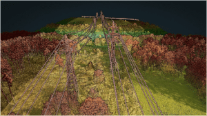
The RANGER-U240 was flown over Big Sandy Creek in Texas for post flood mapping at 250 m AGL, 65 knots. The result was 130 points/square meter, per line.
In July 2025, the Texas Hill Country experienced a devastating and deadly flooding event. As an Austin-based company, the Phoenix LiDAR team felt a strong responsibility to contribute in any way we could. First by volunteering in recovery efforts, and then by deploying our LiDAR technology to capture the effects in the aftermath.
To better understand the impact, our team conducted a manned mission with a Robinson R44 helicopter, deploying the 𝗥𝗔𝗡𝗚𝗘𝗥-𝗨𝟮𝟰𝟬 LiDAR system with a PhaseOne iXM-GS120 camera to capture high-resolution post-flood data.
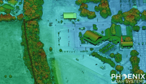
Floods reshape entire communities, and understanding their impact is critical for recovery. Our team captured and processed post-flood LiDAR, creating a dataset that may be of interest to researchers, planners, and engineers working on:
- Flood modeling
- Understanding flood risks
- Infrastructure resilience
- Planning
We’re making this dataset publicly available in hopes it can support anyone who can use it for research, inform cleanup, planning, or long-term flood mitigation.