ResourceType
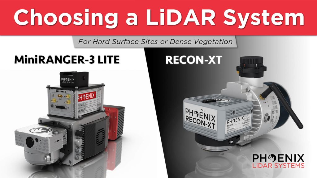
In this video, Kory Kellum from Phoenix LiDAR Systems guides viewers on choosing the right DJI M300 mountable LiDAR solution. He compares the Phoenix Recon XT and the MiniRanger 3, both of which are high-performance, survey-grade systems adaptable for UAV and mobile mapping applications. He also highlights the intrinsic differences between a higher-powered single laser system and a lower-powered multi-laser system to help users understand their specific use cases.
The video showcases real-world applications of these systems. It includes a detailed look at a project site where Scott McGowan from Kestrel Aerial uses the MiniRanger 3 Lite and the Recon XT. The MiniRanger 3 Lite, known for its precision and adaptability, excels in high-density point collection and meets USGS quality level 0 specifications. The Recon XT, valued for its performance in dense vegetation and its wide vertical field of view, is ideal for environments with heavy foliage.
Throughout the video, viewers see practical demonstrations of each system’s capabilities, including data visualization and analysis. The video concludes with a recap, emphasizing the importance of selecting the appropriate LiDAR system for specific project requirements, whether for land development, utility infrastructure, or vegetation mapping.
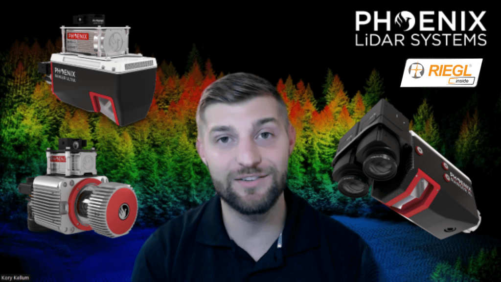
In this video, Kory Kellum from Phoenix LiDAR Systems discusses selecting the right tool for high altitude LiDAR mapping, focusing on the Ranger series. Phoenix LiDAR Systems offers the Ranger XL, Ultra, and Ranger LR, which excel in long-range capability, precision, accuracy, and point density. These systems are the lightest and highest performing on the market, capable of a 1.5 megahertz measurement rate, over a 750-meter range on 20% reflectance targets, and can produce up to 15 returns per pulse, meeting USGS quality level zero specifications.
Kory details the similarities of the Ranger systems, including their weight, performance, and compatibility with UAVs and crewed aircraft, before exploring their differences and specific use cases. The Ranger XL is ideal for high altitude mapping with a wide field of view and fast data acquisition, making it perfect for high point density corridor mapping such as power line, railway track, and pipeline inspection. It has the longest range in the Ranger lineup, suitable for high altitude projects with fixed-wing or rotorcraft.
The Ranger Ultra combines weight, range, accuracy, and pulse rate with a unique forward and rear-looking field of view to minimize laser shadowing. It features a three-faceted mirror for improved vertical surface mapping and is ideal for UAV-based high point density corridor mapping projects requiring precision and accuracy.
The Ranger LR is the most adaptable, designed for demanding mapping applications with a 360-degree field of view, making it compatible with mobile, UAV, and helicopter-based mapping. It can penetrate dense vegetation and offers unparalleled versatility.
Kory emphasizes that the Ranger series provides turnkey solutions for various mapping needs, whether for wide area, corridor, or adaptable mapping applications. He encourages viewers to like, subscribe, and contact the sales team to find the right tool for their specific needs.
Join Kory Kellum, Senior Software Engineer at Phoenix LiDAR Systems, as he explores the advanced capabilities of Phoenix LiDAR’s mapping technology in their May 2022 webinar. Phoenix LiDAR specializes in compact, adaptable, survey-grade systems for various platforms like UAVs, cars, and backpacks, and offers robust post-processing software, including LiDARMill and SpatialExplorer Pro.
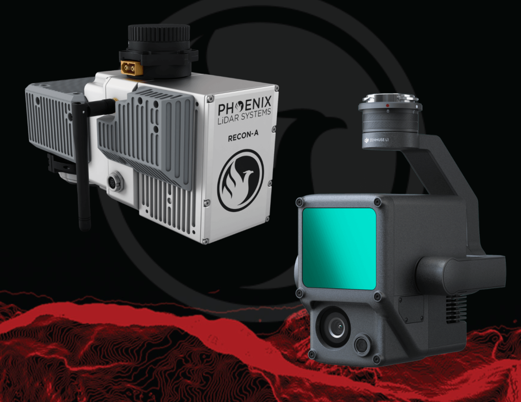
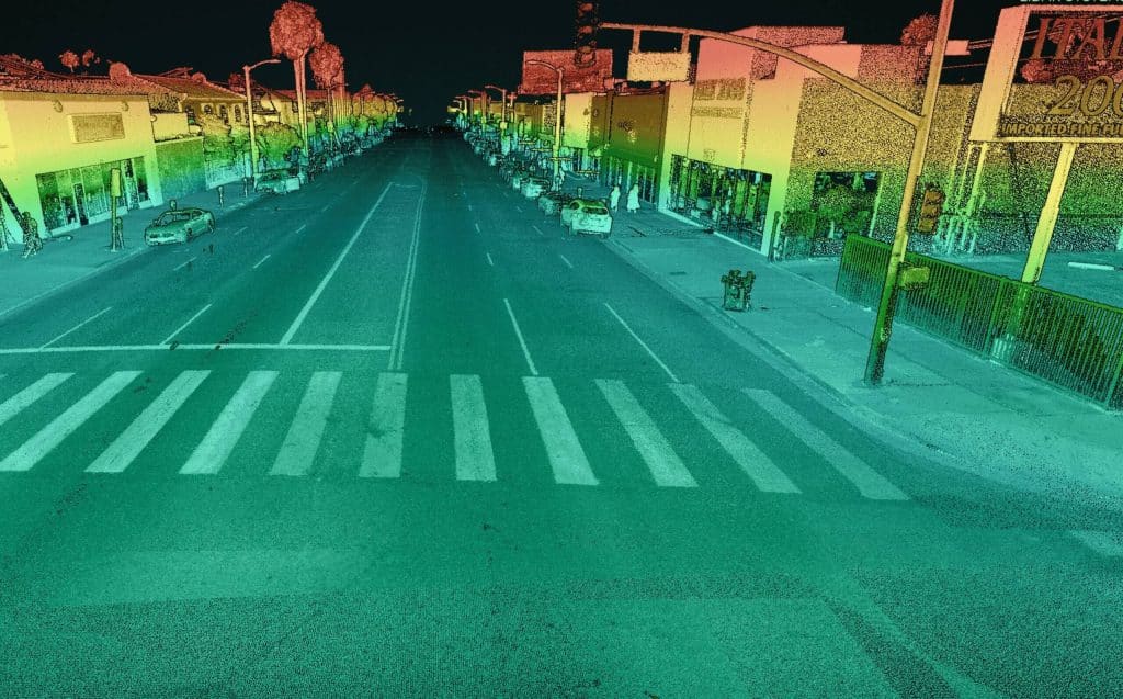
Phoenix LiDAR, based in Austin, Texas, contrasts with DJI’s recent entry into the LiDAR market. Phoenix offers comprehensive solutions, ensuring high-quality data acquisition and processing, supported by robust customer service. The Recon A system, with its superior APS-C camera sensor and vibration dampening kit, is compared to DJI’s Zenmuse L1, which is limited to the Matrice 300. The Recon A’s IMU is notably more accurate, reducing drift and improving data reliability.
Phoenix LiDAR’s LiDARMill offers advanced features like flight line splitting, ground control adjustments, AI classification, and detailed QC reports, which are not available in DJI’s Terra Pro. This comprehensive processing capability ensures high accuracy and quality in deliverable data products. A comparative analysis of data from DJI’s L1 and Phoenix LiDAR’s Recon A showcases significant differences in accuracy and precision. The Recon A system demonstrated superior performance, particularly in terms of reducing warping and improving overall data quality.
For those seeking accurate, high-quality LiDAR solutions, Phoenix LiDAR Systems provides a superior alternative with extensive support and advanced features.
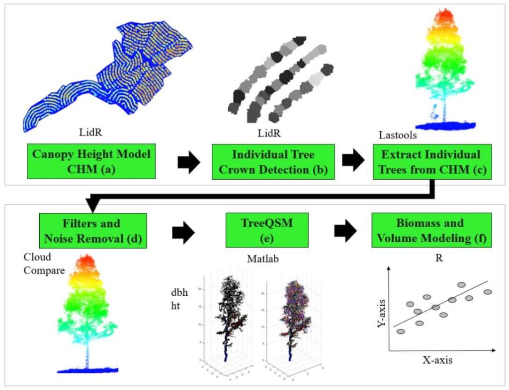
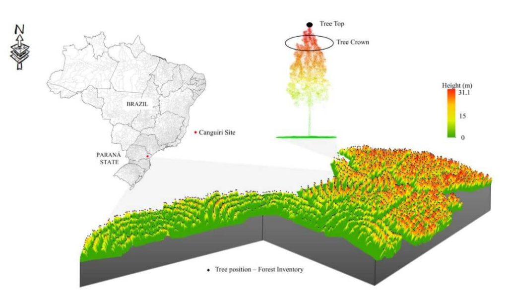
This whitepaper delves into the innovative use of high-density LiDAR data and Quantitative Structure Modelling (QSM) to estimate individual tree attributes, traditionally predicted by field-derived allometric models. Leveraging LiDAR data collected by Unmanned Aerial Vehicles (UAVs), we evaluated the accuracy of QSM in determining key tree metrics such as diameter at breast height (dbh), tree height, volume, and aboveground biomass components (stem, branch, and total).
Our study compares two QSM approaches: integrating QSM-derived dbh and height into field-based equations for volume estimation, and deriving tree volume directly from QSM. Despite a slight overestimation tendency, the models demonstrated satisfactory performance, highlighting QSM’s potential to provide detailed and extensive tree attribute estimates.
This method offers a promising alternative for forest management decision-making, especially in analyzing tree architecture and biomass. The findings underscore the value of UAV-LiDAR and QSM in enhancing the precision and scope of forest attribute assessments.

Join Phoenix LiDAR Systems and SkySkopes for a quick fly through video focused on the RANGER series of helicopter based mapping solutions. SkySkopes is a top-tier data service provider that operates a wide variety of advanced sensors and aircraft for transmission and distribution line inspections, oil and gas applications, and many other innovative use cases that focus on adding value.
Join Kory Kellum, Senior Geomatics Engineer at Phoenix LiDAR Systems, in this February 2022 webinar as he introduces flexible LiDAR mapping solutions tailored to diverse customer needs. Since 2013, Phoenix LiDAR has pioneered innovations like the first commercial UAV LiDAR system and the LiDARMill cloud-based post-processing platform.
Kory highlights the new mobile data processing features in SpatialExplorer 7, emphasizing its high data density, accuracy, and efficiency. Ideal for applications like roadway design, bridge surveys, and asset inventory, mobile LiDAR mapping offers detailed data collection without lane closures or traffic disruptions.
SpatialExplorer 7 provides comprehensive mobile LiDAR processing with robust automated camera and LiDAR calibration, supporting multiple platforms to integrate mobile and aerial data seamlessly. The software includes mission guidance tools for complete data collection, navigation data processing options, and LiDAR Snap 4 for trajectory optimization.
Camera Snap 2 offers automated calibration of 360-degree imagery from the Ladybug camera, featuring custom mask creation and improved RGB extraction. The software generates various quality control reports, ensuring data accuracy and saving users time.
Corey demonstrates a mobile processing workflow in Spatial Explorer 7, covering trajectory clipping, point cloud generation, and calibration. The video concludes with examples of point cloud optimization and classification.
In the Q&A session, Kory and Dr. Ben Adler discuss the capabilities of Phoenix LiDAR’s systems, their applications, data processing options, and integration with other tools. They also highlight the flexibility of Spatial Explorer 7 in handling various data types and supporting different coordinate systems.
This whitepaper presents a novel approach to forest inventory within integrated crop-livestock-forest systems using high-density UAV-LiDAR point clouds. Focusing on Eucalyptus benthamii seed forest plantations, we utilized the GatorEye UAV-LiDAR system to compare two forest inventory methods: Sampling Forest Inventory (SFI) with various plot arrangements and Individual Tree Detection (ITD).
By analyzing a point cloud with over 1400 points per square meter, we assessed basal area and volume estimates using both field and LiDAR-measured heights. We compared the number of trees, basal area, and volume per hectare across different scenarios, using statistical analysis to evaluate accuracy and equivalence. Our results show that the SFI approach with a 2300 m² area provides estimates comparable to the ITD method, with minimal error and improved processing efficiency.
This study offers valuable insights for selecting optimal plot sizes in forest inventories, enhancing precision in integrated crop-livestock-forest systems.
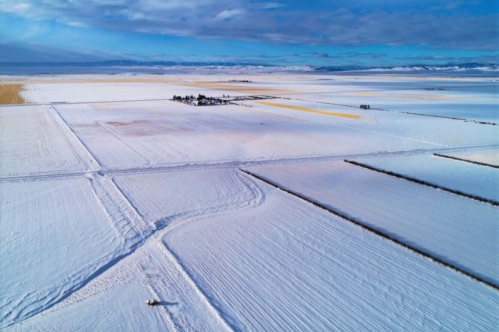
The December 2021 Phoenix LiDAR Systems webinar focused on LiDAR snow surface mapping for NASA’s SnowEx program. Jeff Rizza from DJ&A detailed a 2021 snow surface mapping project using high-resolution drone LiDAR to capture data in Montana’s prairie biome. Highlighting his experience with UAVs and LiDAR, Jeff discussed DJ&A’s collaboration with NASA and Montana State University to improve snow data collection methods.
The webinar covered Phoenix’s LiDAR systems, cold-weather challenges, and innovative survey methods for accurate snow surface mapping. Jeff showcased data insights on snow dynamics influenced by wind and vegetation and discussed processing challenges using Phoenix’s SpatialExplorer and Terascan software. The Q&A session addressed equipment, data processing, and unique SnowEx project aspects. Jeff also previewed an upcoming white paper comparing LiDAR and photogrammetry, highlighting LiDAR’s advantages in vegetation-dense areas.
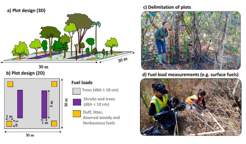
This whitepaper explores a groundbreaking framework for quantifying fuel load in fire-prone regions, focusing on the Brazilian tropical savanna (Cerrado biome), using NASA’s GEDI full-waveform spaceborne LiDAR sensor. Understanding fuel load is crucial for integrated fire management, preserving carbon stock, biodiversity, and ecosystem functioning, and assessing global climate regulation. Traditional remote sensing methods lack the capability to measure vertical vegetation structure accurately.
Our study leverages UAV-collected LiDAR data to simulate GEDI full-waveforms, from which we derive vegetation structure metrics. These metrics are then correlated with field-measured fuel load components using Random Forest models. The resulting models, which predict woody and total fuel loads with high accuracy (R² = 0.88 and 0.71, respectively), provide reliable estimates even for lower strata components.
This innovative approach allows for the creation of fuel load maps for the entire Cerrado and can be extended to other fire-prone regions, enhancing fire management and carbon monitoring efforts. This research showcases the potential of spaceborne LiDAR to revolutionize environmental management and climate initiatives in tropical savannas and beyond.