ResourceType
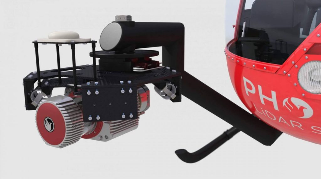
Discover the innovative vehicle-flexible systems by Phoenix LiDAR Systems, as presented by senior post-processing engineer Kory Kellum in the February 2021 webinar. Phoenix LiDAR Systems, a leader in UAV-based LiDAR technology, offers 3D mapping systems adaptable to various vehicles, including UAVs, cars, backpacks, and helicopters.
These multi-vehicle LiDAR payloads are crucial for industries like construction, mining, forestry, and utilities. Kory Kellum delves into the benefits of transferring payloads between vehicles, utilizing UAVs for site accessibility and dense data collection, cars for roadside asset mapping, and helicopters for wide-area coverage. Learn about the importance of system mounts, custom cables, and calibration for seamless transitions, as well as tackling challenges like sensor orientation and precise measurements.
The webinar also provides practical examples of combining different vehicles and LiDAR systems for comprehensive mapping. Concluding with a Q&A session, Kory addresses questions on LiDAR systems, data collection, and tailored solutions, highlighting Phoenix LiDAR Systems’ commitment to customized support and training.
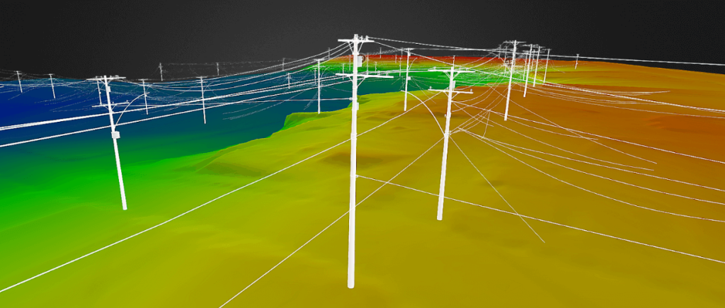
Join Iram Unfold from Phoenix LiDAR Systems as he delves into the transformative power of LiDAR and UAV technology for power line surveys. This comprehensive webinar covers every aspect of a survey project, from initial client interactions and RFP responses to precise data acquisition, post-processing, and final deliverables.
Discover how Phoenix LiDAR Systems’ compact, customizable LiDAR mapping systems, known for their high accuracy and 3D imaging capabilities, can revolutionize utility industry applications. Learn through a fictional case study about “Stuart’s Utility Company” and explore key considerations for sensor specifications, mission planning, and the integration of weather station data for accurate wire loading models.
Iram emphasizes the importance of accurate data acquisition, effective post-processing, and the generation of actionable insights. The session also includes a Q&A segment addressing ground control points, trajectory matching, and sensor recommendations.
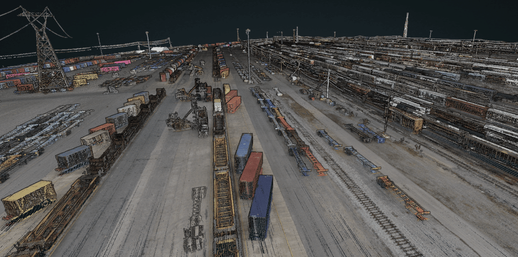
Join Kory Kellum in this insightful Phoenix Lidar Systems webinar featuring experts from CSX and American Rail Engineers (ARE) as they discuss the transformative use of mobile and UAV-based LiDAR in rail applications. Phoenix LiDAR Systems, a leader in commercial UAV LiDAR technology, offers custom LiDAR mapping systems for various platforms. This webinar explores how CSX and ARE leverage these advanced systems for asset inventory, change management, vegetation management, hydrology mapping, and more.
CSX representatives Steve Carmody and Tony Boise share their journey from manual data collection to utilizing mobile LiDAR units (Scout 16s) and permanently installed units (HDL 32s), significantly enhancing efficiency and safety. They also discuss plans to expand their capabilities with aerial LiDAR for complex environments like railroad yards.
ARE experts Steven Ushak, Taylor Engel, and Sam Johnson highlight their successful use of the Mini Ranger system for projects such as coastal resilience studies and PTC vegetation cutback planning. They emphasize LiDAR’s ability to penetrate vegetation and collect data in challenging conditions, including nighttime operations, and discuss future upgrades to larger systems for broader coverage and higher resolution.
The webinar underscores the critical improvements LiDAR technology brings to the rail industry, showcasing various applications and the potential for further advancements with aerial LiDAR and beyond visual line of sight operations. Concluding with a Q&A session, the discussion addresses data accuracy, field-to-office workflows, and operational challenges in diverse environments.
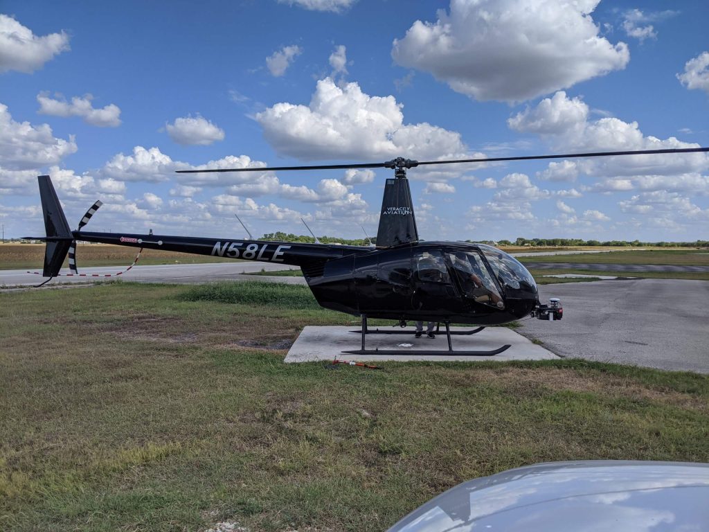
Join the Phoenix LiDAR Systems September 2021 webinar, hosted by Conrad Conterno and Ben Adler, focusing on airborne LiDAR data acquisition with manned aircraft. This session highlights the advantages of using fixed-wing aircraft and helicopters for LiDAR mapping, including increased flight speed, height, and the ability to cover large areas efficiently. Conrad Conterno, the post-processing manager, and Ben Adler, CTO and co-founder, introduce the new mission guidance feature of SpatialExplorer, a software that enhances real-time flight mission execution.
Learn about the different mission types available in the flight planner, such as wide-area mapping, corridor mapping, and line points mode. Discover how to incorporate various sensor types and models for accurate planning, ensuring optimal density, overlap, and resolution. The webinar includes a detailed demonstration of MissionGuidance, showcasing tools like dynamic whiskers for real-time navigation and the touch-and-go mode for pilot-initiated flight lines.
Understand the importance of precise flight planning and execution for high-quality LiDAR data and efficient post-processing. The session concludes with a Q&A, addressing flight plan creation, altitude calculations, and system adaptability. Explore the future of LiDAR mapping with Phoenix LiDAR Systems’ advanced technology and mission guidance capabilities.
The proliferation of unmanned aerial vehicles (UAVs) over the past decade has been driven by advancements in structure-from-motion (SfM), machine learning, and robotics. A crucial application in forestry is individual tree detection (ITD), essential for calculating forest attributes like stem volume, forest uniformity, and biomass estimation.
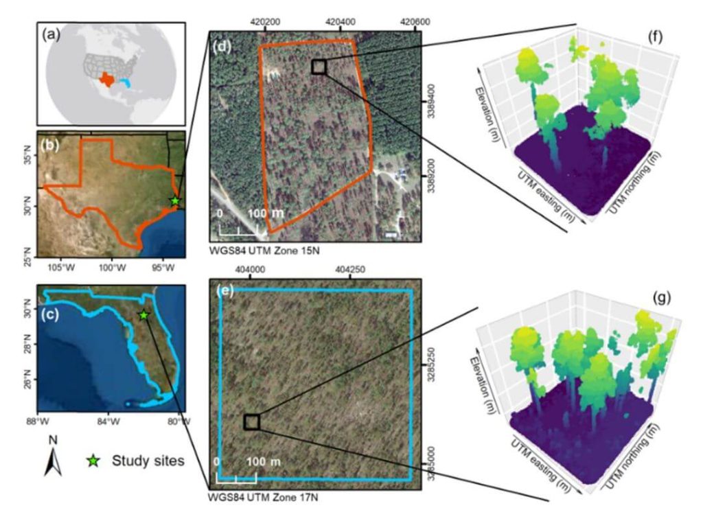
This whitepaper addresses the challenges users face in adopting UAVs and algorithms for specific projects by providing a detailed tutorial for performing ITD. It covers the use of low-cost UAV-derived imagery and UAV-based high-density LiDAR, utilizing open-source R packages to develop a canopy height model (CHM) and implement the local maxima (LM) algorithm for ITD.
Accuracy assessments are derived through manual visual interpretation and field-data validation. Targeted at beginners in remote sensing, this guide employs a simple methodology and uses study plots with relatively open canopies. Supplementary materials include R codes and sample plot data to facilitate practical application.
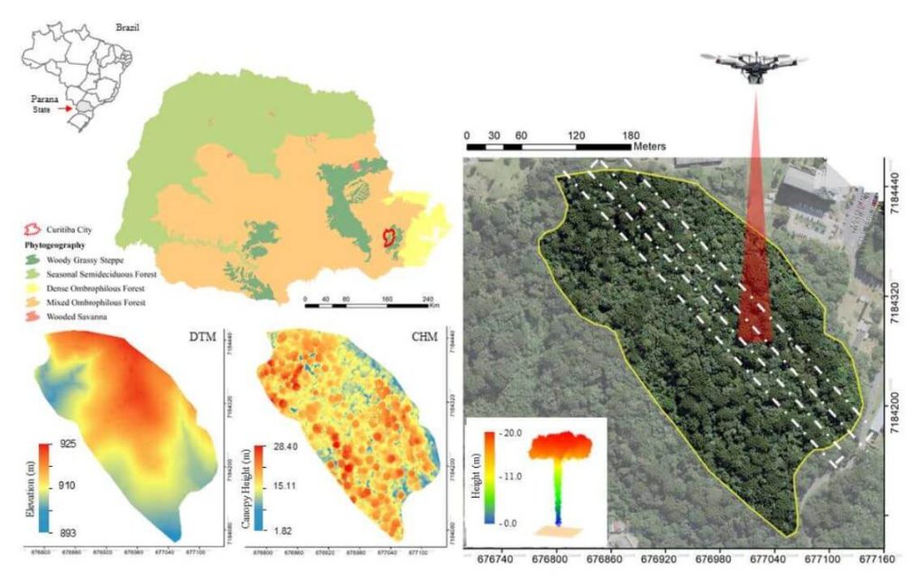
This whitepaper explores the role of urban forest remnants in mitigating climate change by reducing carbon dioxide levels in urban areas. Specifically, it focuses on the potential of UAV-LiDAR systems to accurately measure individual tree heights in an Urban Atlantic Forest, using Araucaria angustifolia trees as a case study.
Through detailed analysis, the study assesses the impact of varying point densities (ranging from 2,500 to 5 returns per square meter) on the accuracy of tree height measurements. The findings reveal that higher point densities provide more precise tree profiles, while lower densities result in gaps in the Crown Height Model (CHM). The research highlights that the optimal point density for the highest agreement between UAV-LiDAR -derived and field-based tree heights is 100 returns per square meter, with the lowest relative root mean square error (rRMSE) observed at 50 returns per square meter.
This whitepaper underscores the effectiveness of UAV-LiDAR technology in urban forest management and its implications for developing policies to maintain essential ecosystem services.
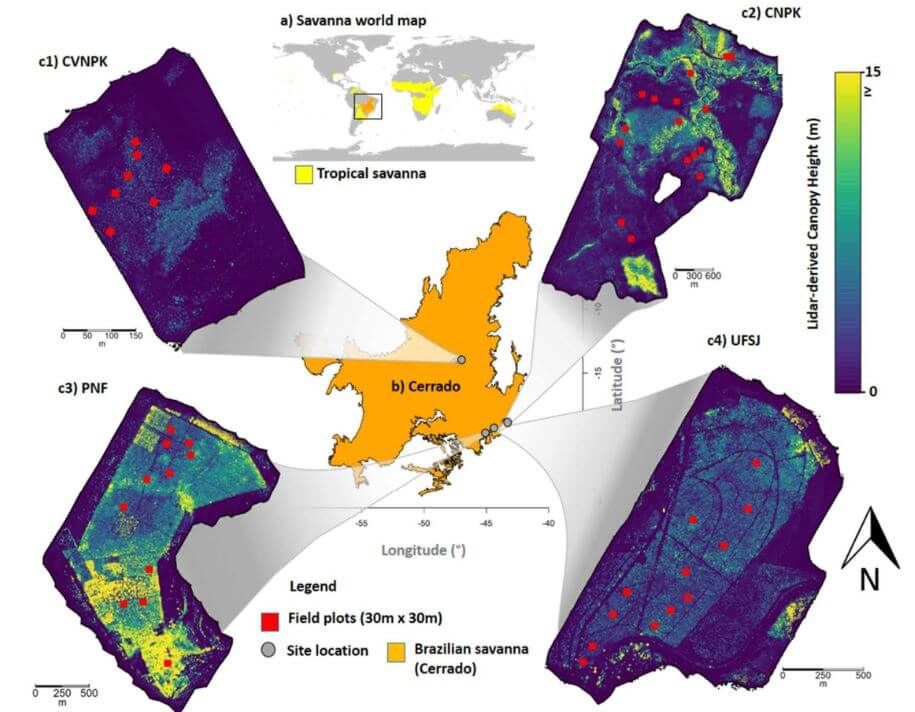
This whitepaper delves into the pivotal role tropical savanna ecosystems play in the global carbon cycle, particularly focusing on the Brazilian Savanna (Cerrado). It examines the uncertain capacity of these ecosystems to store and sequester carbon due to the intertwined effects of human activities and climate change. Utilizing high-density UAV-LiDAR technology, this study provides a comprehensive analysis of the above ground biomass density (AGBt) across diverse vegetation formations in Cerrado, including forests, savannas, and grasslands.
The research highlights the development and validation of regression models to estimate AGBt, emphasizing the model that incorporates vegetation height and cover as the most effective, achieving an adjusted R2 of 0.79. This model was used to map AGBt over a vast area, demonstrating the feasibility and potential of UAV-LiDAR in accurately estimating biomass. Additionally, the study underscores the necessity for improved biomass estimation in grasslands to enhance the understanding of the global carbon balance and support integrated fire management.
The findings presented in this whitepaper provide critical insights and benchmarks for future research, aiming to generate precise biomass maps and inform effective carbon emission mitigation strategies in tropical savanna ecosystems.
This whitepaper investigates the innovative use of UAV-borne hyperspectral and LiDAR data to enhance our understanding of forest ecosystem restoration. Focusing on twelve 13-year-old restoration plots in the Brazilian Atlantic Forest, the study evaluates the effectiveness of these technologies in assessing tree diversity and structure.
By combining LiDAR -derived structural attributes—such as canopy height and leaf area index (LAI)—with hyperspectral variables, the research demonstrates the complementary nature of these data sources. The findings reveal that while LiDAR -derived canopy height is a strong predictor of above ground biomass (AGB), the integration of hyperspectral and LiDAR data provides a comprehensive approach to monitoring forest structural attributes and tree diversity. The study supports biodiversity theory, showing that higher species richness enhances biomass capture and canopy functionality.
This whitepaper underscores the critical role UAV-borne remote sensors can play in large-scale forest monitoring, particularly in the context of the UN Decade of Ecosystem Restoration, by providing high-resolution data essential for effective decision-making in restoration projects.
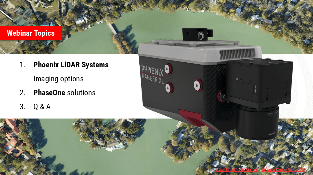
Join the Phoenix LiDAR Systems webinar on advanced imaging systems, held on April 21, 2021. Hosted by Conrad Conterno, Head of Post-Processing, and Justin Wyatt, VP of Sales at Phoenix LiDAR Systems, along with Nick Nelio, Inspection Sales Manager for Phase One, this session dives into how Phoenix LiDAR’s data collection tools integrate with Phase One’s cutting-edge imaging systems to enhance remote sensing capabilities.
Conrad Conterno opens with an overview of Phoenix LiDAR’s custom mapping solutions, emphasizing LiDAR sensor integration for superior data acquisition and analysis. He introduces various advanced camera options, including the lightweight custom A6K Light for UAV-based mapping, dual oblique cameras for enhanced colorization, multispectral solutions for detailed vegetation analysis, thermal mapping cameras for environmental monitoring, and hyperspectral sensors for precise spectral analysis.
Nick Nelio then showcases Phase One’s high-resolution, medium-format cameras, focusing on the 4-band solution that combines RGB and near-infrared imagery, ideal for crop analysis and environmental monitoring. He also presents the Phase One P3 payload for inspection applications and the IX Mach 5 controller designed for efficient geospatial missions.
Throughout the webinar, the benefits of direct geo-referencing and the seamless integration of multiple sensors into single payloads are highlighted. The hosts address audience questions on the accuracy of dual-camera systems, post-processing challenges, and the applications of hyperspectral imaging.
The session concludes with Justin Wyatt and Nick Nelio emphasizing their collaborative approach to delivering tailored solutions and inviting viewers to contact them for personalized consultations.