
Resource Type
Industry
Product Group
Phoenix LiDAR Systems proudly announces the upcoming release of our new enhanced SpatialSuite 5.0. We discussed and showcased many of the powerful new tools and features in SpatialExplorer 5.0. This Webinar took place on December 18, 2019 at 11 am PST and was led by Post Processing Manager, Conrad Conterno and LiDAR Applications Engineer, Walter Galan.
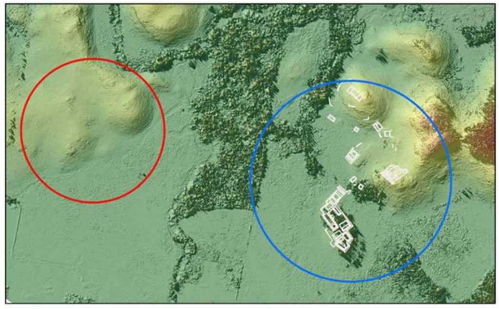
This whitepaper presents groundbreaking insights into the architectural details of the ancient Raleigh Island shell-ring complex (8LV293) on the Gulf Coast of Florida, revealed through drone-mounted, high-resolution LiDAR technology.
Dating back to 900 to 1200 CE, this settlement features at least 37 residential spaces enclosed by oyster shell ridges up to 4 meters tall. Excavations in ten of these spaces uncovered extensive evidence of shell bead production from marine gastropods, highlighting the island’s role in the political economies of second-millennium CE chiefdoms across eastern North America. Unlike other regions where shell bead production was controlled by chiefs, Raleigh Island’s bead making operated independently.
The high-resolution drone LiDAR data allows for unprecedented comparisons of bead production activities across different residential spaces, providing valuable analytical perspectives on the organization of ancient shell bead production. This study underscores the potential of drone-mounted LiDAR in enhancing our understanding of ancient political economies and settlement architectures.
This whitepaper details the use of unmanned aerial vehicle (UAV) LiDAR missions conducted in the Maya Lowlands between June 2017 and June 2018 to develop effective methods, procedures, and standards for drone LiDAR surveys of ancient Maya settlements and landscapes.
Testing at three site locations in the upper Usumacinta River region—Piedras Negras in Guatemala (2017) and Budsilha and El Infiernito in Mexico (2018)—provided a diverse range of natural and cultural contexts to evaluate the technology’s field utility. The study’s results, based on standard digital elevation and surface models, demonstrate the effectiveness of drone LiDAR for documenting ancient landscapes and settlements across the Maya Lowlands and Latin America.
This approach is adaptive, cost-effective, and suitable for targeted documentation, though it requires careful planning and sample evaluation. Future research will further refine the methods and techniques for data filtering and processing.
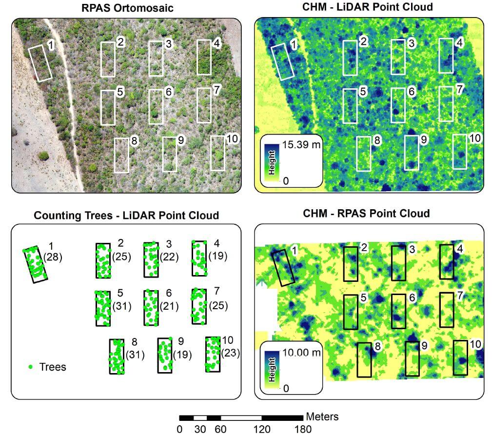
This whitepaper explores the application of Remotely Piloted Aircraft Systems (RPAS) equipped with RGB and LiDAR sensors for monitoring the Brazilian savanna, known as the Cerrado. The Cerrado is the most biologically diverse savanna globally, facing significant threats from anthropogenic activities, necessitating effective environmental policies. This study demonstrates the potential of these advanced sensing technologies for the physical characterization of landscapes within the Cerrado biome.
The research includes analyses of vegetation structure, where the automatic counting of trees was performed. Results indicated that the average tree height measured by RGB sensors was significantly lower than that obtained by LiDAR sensors, highlighting the limitations of Structure from Motion data in densely vegetated landscapes.
The LiDAR data enabled accurate tree counting, with 1,825 trees identified across the study area and 245 within specific ecological study parcels. This paper underscores the effectiveness of RPAS in reducing the costs and time associated with environmental surveys and evaluations, providing crucial insights for the development of conservation policies in the Cerrado.
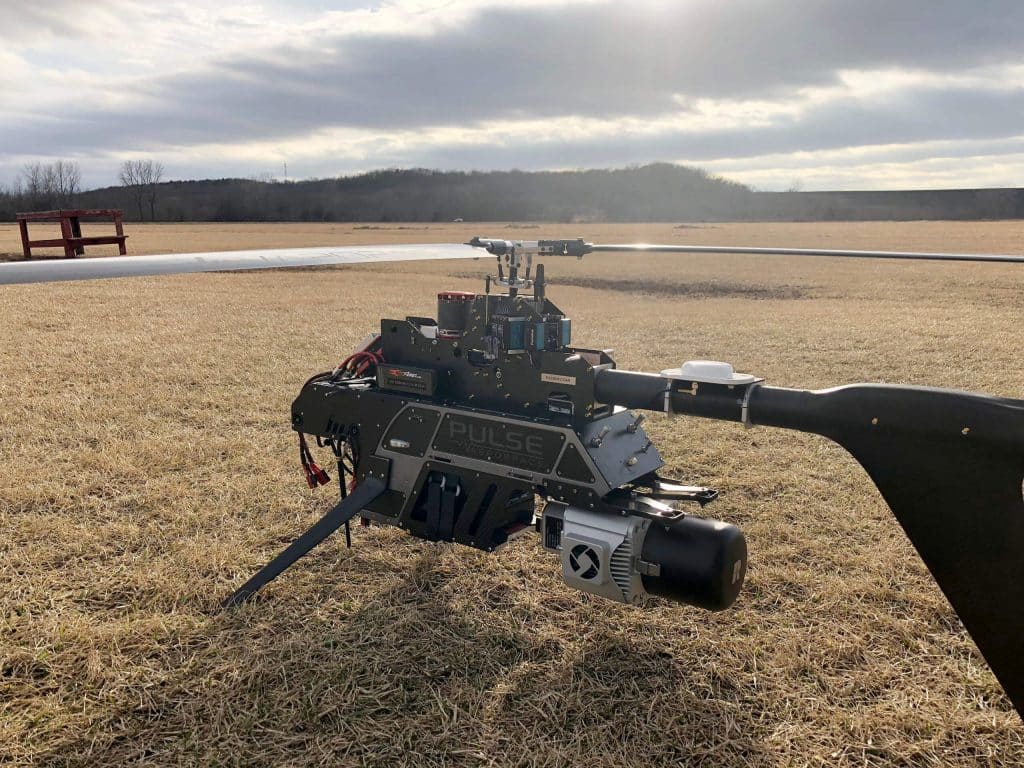
This whitepaper presents the initial results from testing and evaluating a single-rotary Unmanned Aircraft System (UAS) integrated with a long-range, multi-return LiDAR sensor. Conducted at an airfield in South Texas, USA, the study explores the evolving capabilities of miniaturized LiDAR technology and its application in UAS platforms. Compared to traditional airborne LiDAR mapping, UAS platforms offer greater flexibility in flight design, rapid response capabilities, and potentially lower costs for local mapping.
The research focuses on describing the UAS platform and its enabling technologies (LiDAR, IMU, GPS), sensor calibration and initialization processes, and the methods for geospatial surveying, data processing, and analysis. The advantages of LiDAR, such as its pulsed ranging technique and multi-return detection capability, are highlighted, demonstrating its effectiveness in applications like vegetation structure monitoring, obstacle detection, and digital terrain model refinement.
This study underscores the potential of UAS LiDAR systems for fine-scale mapping and various environmental monitoring applications, paving the way for enhanced precision and efficiency in geospatial data collection.
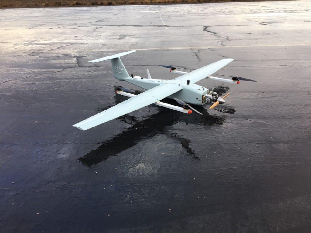
Join Phoenix LiDAR Systems in their fourth webinar, introducing the company’s cutting-edge, survey-grade LiDAR mapping systems and automated processes. Discover their pioneering achievements, including the world’s first fixed-wing VTOL UAV LiDAR system. This webinar delves into challenging UAV LiDAR applications, such as powerlines, dense vegetation, corridor mapping, and wide-area mapping. Sam, the chief pilot, highlights the capabilities of the TerraHawk CW-20 and CW-30 fixed-wing VTOL UAVs, known for their long flight durations, RTK positioning, and flexible takeoff and landing.
Grayson Omans, CEO, underscores the importance of extended airborne LiDAR operation and efficient system integration. Senior Post-Processing Manager, Conrad, showcases impressive datasets from various terrains, demonstrating the high-density lidar data captured by the TerraHawk UAVs and Scout Ultra and Ranger LRT systems.
The team addresses viewer questions, and Eric Agnello, Director of Sales, announces the Scout series relaunch with new sensor options. The webinar concludes with details on upcoming events and an invitation for feedback and future webinar topic suggestions.
Join Phoenix LiDAR Systems’ latest webinar where Director of Marketing Vu Winn discusses UAV LiDAR post-processing tips and tricks. Designed to provide continuing education and streamline LiDAR data collection, this session highlights Phoenix’s pioneering role in developing the first commercial UAV LiDAR system and their ongoing technological innovations.
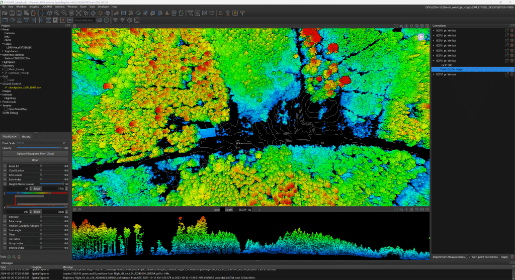
LiDAR post-processing engineer Eric McNeil showcases essential software tools such as SpatialExplorer, Inertial Explorer, and the cloud-based LiDARMill. Eric covers critical steps from initial field checks to detailed trajectory processing, making complex tasks accessible even to beginners. Viewers gain insights into accurate data handling, troubleshooting, and optimization techniques.
The webinar also includes a Q&A session addressing specific software features and techniques. Concluding with updates on upcoming events and an invitation for feedback, the Phoenix LiDAR Systems team remains available to support attendees.
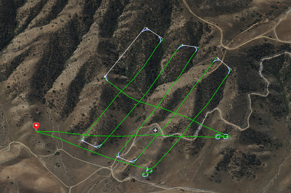
Join Phoenix LiDAR Systems in this informative webinar where Vu Winn, Director of Marketing, emphasizes ongoing education and value for their global client base. The focus is on UAV LiDAR flight planning and best practices for data collection. Chief Pilot Sam Girardi, with 25 years of drone flying experience, demonstrates the Phoenix FlightPlanner software, detailing the process of creating flight plans, setting LiDAR parameters, and ensuring safe data collection.
Key topics include the importance of pre-flight checks, smooth turns, and terrain following. Sam also discusses the significance of testing flight paths with smaller drones and proper lithium battery safety. The team, including post-processing engineer Erik McNeil and sales director Eric Agnello, addresses audience questions on elevation model accuracy, LiDAR versus photogrammetry flight planning, and Litchi software capabilities.
The webinar concludes with an invitation to explore the Phoenix FlightPlanner, a preview of new products like the expanded Scout series and MiniRanger series, and upcoming features in LiDARMill. Stay connected for updates and send feedback for future webinars.
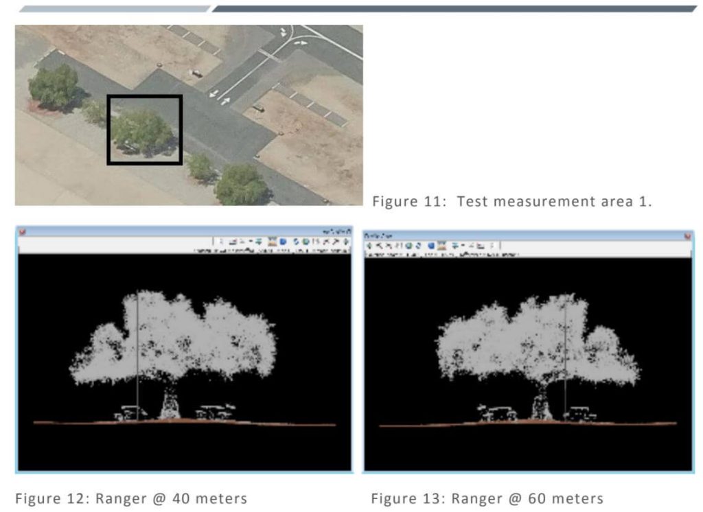
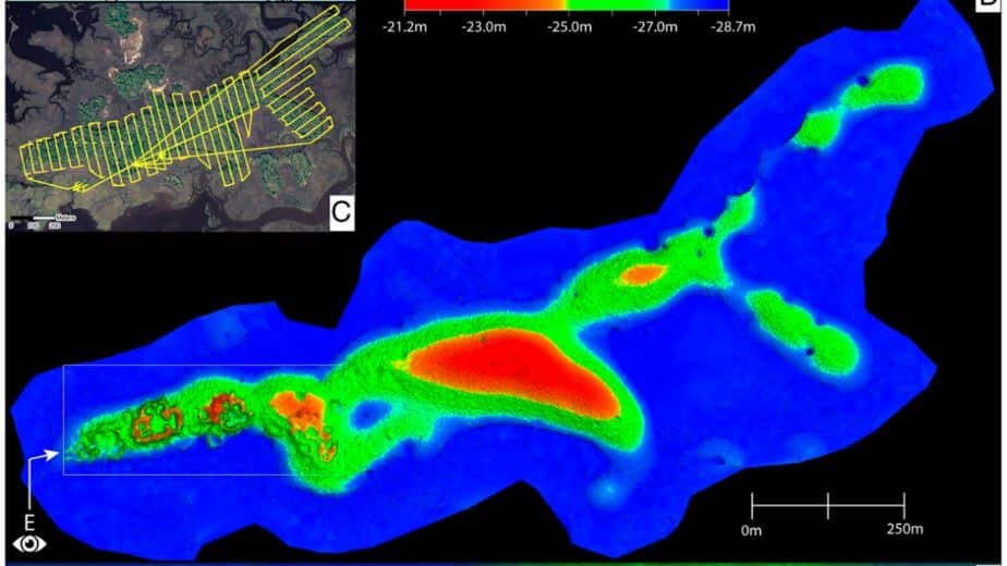
This whitepaper details the calibration testing conducted under task order G17PD01249: Alaska Critical Infrastructure UAV Airfield Obstruction Survey. The Dewberry team, in collaboration with Compass Data and Phoenix LiDAR, performed LiDAR sensor tests for the Kiana and Nulato Airfields. The testing involved the acquisition and post-processing of LiDAR data using two sensors, each flown at two different heights above ground.
The study aimed to assess the sensors’ ability to meet project specifications, including data formatting, LAS point cloud data, smooth surface repeatability, relative accuracy, and intensity values. Additionally, the tests evaluated LiDAR density to determine the optimal sensor and flying height for identifying obstructions, geometric calibration for measurement accuracy and repeatability, radiometric testing for detecting small or low-reflectance obstructions, and measurement consistency across multiple flights.
The findings of this comprehensive testing are documented in this report, providing valuable insights into the performance and reliability of UAV-based LiDAR systems for airfield obstruction surveys.