Engineering
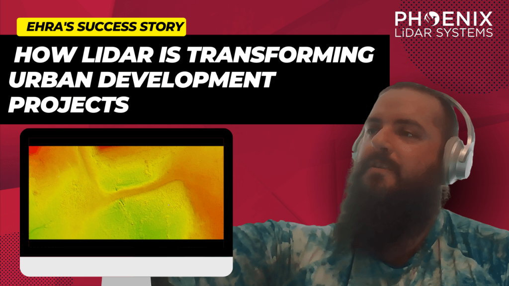
Discover the revolutionary impact of LiDAR technology in urban development with EHRA’s utilization of the Mini-Ranger LiDAR system. In this video, learn how EHRA, a leading engineering firm, leverages drone LiDAR for advanced urban planning and project management.
The Mini-Ranger system is celebrated for its precision in terrain and vegetation mapping, facilitating rapid and accurate data collection that drives efficient, cost-effective project outcomes.
Join Aaron Kelsey, EHRA’s Senior Survey CAD Tech and Drone Program Manager, as he discusses the system’s transformative effects on large-scale surveying—reducing both time and labor costs significantly. He also highlights its crucial role in flood prevention by providing detailed elevation data for effective drainage and water flow management.
The video also explores the evolution of surveying from traditional methods to cutting-edge GPS and LiDAR technologies, enhancing the reliability of data collection. With Phoenix LiDAR’s support, EHRA continues to push boundaries in urban engineering, making significant strides in project accuracy and efficiency.
Discover the groundbreaking impact of LIDAR technology in urban development with EHRA’s innovative use of the Mini-Ranger LIDAR system. In this insightful video, we delve into how EHRA, a leading engineering firm, leverages the power of Drone LIDAR and the MiniRanger system to revolutionize urban planning and project management.

In this informative video, Angela Livingston from Pape-Dawson Engineers, a leading firm in civil engineering and LiDAR services, shares her extensive experience and insights. Pape-Dawson Engineers has been around for over 50 years, expanding their operations across various locations in Texas and Florida. Angela, with a strong background in photogrammetry, LiDAR, and GIS, explains how the company has integrated LiDAR technology into their workflows to enhance efficiency and accuracy in land development projects. The company now utilizes multiple UAVs and LiDAR scanners, including the Phoenix Recon XP, Ranger VUX, and Ranger Ultra, to cater to diverse project needs.
Angela dives into the decision-making process behind choosing specific LiDAR systems based on factors such as vegetation, site size, and project requirements. She explains the strategic use of both drones and helicopters for LiDAR data acquisition, depending on the project’s scope and environmental conditions. This flexibility allows Pape-Dawson to efficiently handle larger projects, such as wastewater treatment plant expansions, and significantly reduce time and costs compared to traditional terrestrial scanning methods. Angela emphasizes the importance of selecting the right tool for the job to achieve the best results.
The video also covers the crucial aspect of standardized workflows and data processing techniques that Pape-Dawson employs. Angela highlights how having a well-defined process ensures high-quality and accurate deliverables for engineering projects. She explains their method of using Phoenix’s Spatial Explorer and Inertial Explorer for navigation processing, followed by Terra Solid and MicroStation for point cloud fusion and feature extraction. This meticulous approach allows Pape-Dawson to maintain consistency and reliability in their data outputs, which is essential for supporting their engineers’ work.
Towards the end of the video, Angela expresses her appreciation for the support and collaboration with Phoenix LiDAR Systems, noting how their responsiveness to feedback has led to hardware and software improvements. She encourages viewers to reach out to her via email for advice on project collection and sensor selection. Angela’s expertise and willingness to share her experiences provide a valuable resource for anyone looking to enhance their engineering projects with advanced LiDAR technology. For those interested, Angela can be contacted through Pape-Dawson’s website or directly via email.
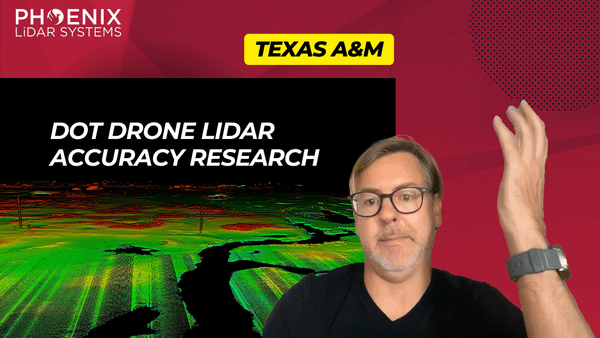
This video features Professor Michael Starek from Texas A&M University-Corpus Christi, as he discusses the innovative use of drone LiDAR technology by geomatics students to map and protect coastal habitats.
Through a detailed interview, Professor Sterk explains how they employ Phoenix LiDAR systems, including the high-end Ranger LR and the cost-effective Recon XT-A, to accurately measure microtopographic changes in sensitive wetland areas.
These drone-based systems provide crucial data for understanding coastal erosion, vegetation dynamics, and the impacts of sea level rise, with a focus on precision and the ability to capture minute changes in terrain that are vital for environmental monitoring and conservation.
The video highlights the practical applications of LiDAR in geomatics, demonstrating its significance in environmental science and the advantages of using drones over traditional aircraft for detailed and localized data collection. Professor Sterk emphasizes the career opportunities in geomatics, noting the high demand for trained professionals in this growing field.
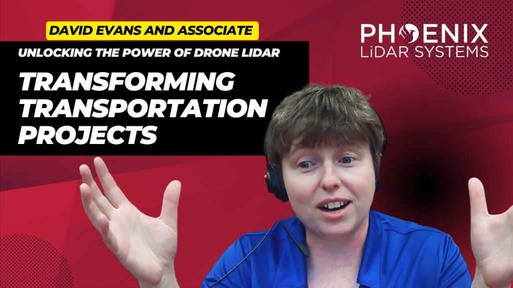
Explore the transformative impact of Drone LiDAR technology in revolutionizing transportation infrastructure and environmental restoration. This video delves into how high-precision LiDAR mapping is becoming essential in transportation projects, enhancing accuracy in capturing topography and uncovering hidden utilities for better planning and execution.
Featuring real-world applications from industry leaders like David Evans and Associates, and hydrological projects led by Evan Radford, the video highlights the wide-ranging benefits of this technology.
Discover how Drone LiDAR reduces workload, improves safety for field crews through aerial scanning with drones and helicopters, and accelerates data collection. We also discuss the integration of aerial scanning with ground surveying to ensure unparalleled data accuracy and detail, crucial for comprehensive project success.
Additionally, we examine the role of advanced LiDAR software tools, like strip matching, in ensuring data quality and precision. This exploration is designed to equip professionals across industries with insights into the capabilities and advantages of Drone LiDAR technology in transforming transportation planning and environmental efforts.
Unlocking the Power of Drone LiDAR: Transforming Transportation Projects. The world of transportation infrastructure is undergoing a profound transformation, and at the heart of this revolution is Drone LiDAR technology. This groundbreaking innovation is fundamentally reshaping the way we approach transportation projects, providing unparalleled precision and accuracy in high-precision mapping. In our comprehensive exploration, we delve into the captivating realm of Drone LiDAR. We start by unraveling the core concepts, introducing you to the technology’s essence, and highlighting why it’s becoming an indispensable tool in various industries.
This is a panel discussion featuring two Surveying and Engineering Design service providers: EHRA and Wood Rodgers. We will discuss how they are leveraging Phoenix LiDAR’s systems to perform the heavy lifting in order to provide both the fastest data acquisition and best data deliverables to their clients. You won’t want to miss hearing their many compelling successes throughout their LiDAR-based Surveying and Engineering Design workflows.
We’re excited to announce the release of LiDARMill v2! LiDARMill v2 takes automated post-processing to the next level. In our recent webinar, we covered some of the new improvements and features including:
- Imagery Processing in LiDARMill
- Ground Control Reporting and Adjustments
- Robust Coordinate System Handling
- A Workflow Overview and Demonstration
- Multi-Mission Processing Support
- Advanced Point Cloud Filtering Options
- RGB Thermal & Fusion
- Accuracy Reporting
- Automated LiDAR and Camera Calibration Options
- Near-Real Time (NRT) Reference Station Positioning for Projects Requiring Less Than 24 Hour Turn-around Time
- Trajectory Post-Processing Without Reference Stations
If you have any questions or would like to learn more about LiDARMill v2, please don’t hesitate to get in touch. We’d be happy to help!
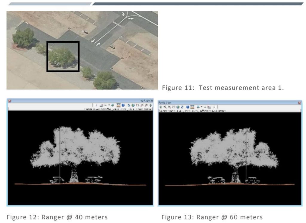
This whitepaper presents the initial results from testing and evaluating a single-rotary Unmanned Aircraft System (UAS) integrated with a long-range, multi-return LiDAR sensor. Conducted at an airfield in South Texas, USA, the study explores the evolving capabilities of miniaturized LiDAR technology and its application in UAS platforms. Compared to traditional airborne LiDAR mapping, UAS platforms offer greater flexibility in flight design, rapid response capabilities, and potentially lower costs for local mapping.
The research focuses on describing the UAS platform and its enabling technologies (LiDAR, IMU, GPS), sensor calibration and initialization processes, and the methods for geospatial surveying, data processing, and analysis. The advantages of LiDAR, such as its pulsed ranging technique and multi-return detection capability, are highlighted, demonstrating its effectiveness in applications like vegetation structure monitoring, obstacle detection, and digital terrain model refinement.
This study underscores the potential of UAS LiDAR systems for fine-scale mapping and various environmental monitoring applications, paving the way for enhanced precision and efficiency in geospatial data collection.
This whitepaper details the calibration testing conducted under task order G17PD01249: Alaska Critical Infrastructure UAV Airfield Obstruction Survey. The Dewberry team, in collaboration with Compass Data and Phoenix LiDAR, performed LiDAR sensor tests for the Kiana and Nulato Airfields. The testing involved the acquisition and post-processing of LiDAR data using two sensors, each flown at two different heights above ground.
The study aimed to assess the sensors’ ability to meet project specifications, including data formatting, LAS point cloud data, smooth surface repeatability, relative accuracy, and intensity values. Additionally, the tests evaluated LiDAR density to determine the optimal sensor and flying height for identifying obstructions, geometric calibration for measurement accuracy and repeatability, radiometric testing for detecting small or low-reflectance obstructions, and measurement consistency across multiple flights.
The findings of this comprehensive testing are documented in this report, providing valuable insights into the performance and reliability of UAV-based LiDAR systems for airfield obstruction surveys.
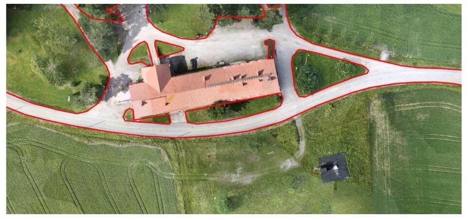
This whitepaper outlines the objectives and results of a test campaign aimed at evaluating the accuracy of point clouds generated by Phoenix LiDAR Systems in a realistic survey mission scenario. The study also tested the performance of Terrasolid software, running on MicroStation CONNECT Edition, for calibrating and enhancing the data.
Data sets were acquired using a Camflight FX8HL UAS platform and pre-processed into trajectory and point cloud files using Phoenix LiDAR Systems software. The findings demonstrate the effectiveness of these technologies in producing accurate and reliable data for various survey applications, highlighting the potential for improved data calibration and processing with the integrated software solutions.
This report provides valuable insights into the capabilities and performance of UAV-based LiDAR systems for high-precision surveying and mapping tasks.