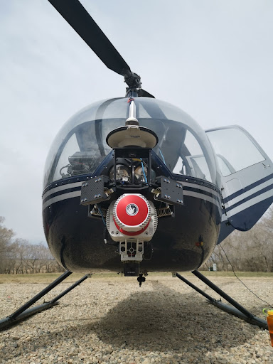
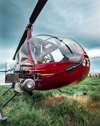
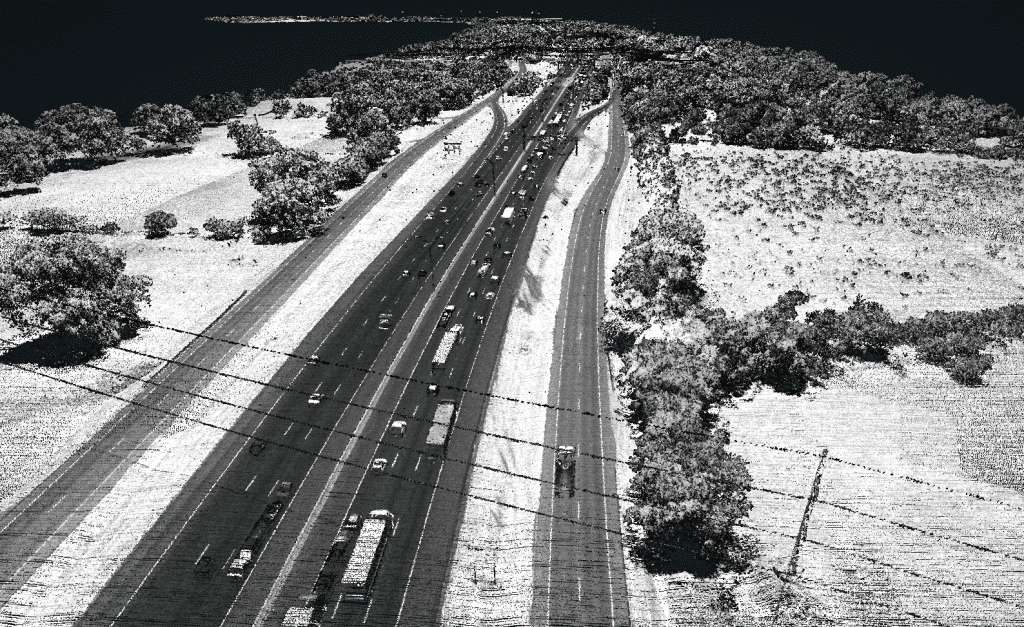
LiDAR
Speed: 8 m/s
Point density: ~250 points/m² per line
AGL: 120 m
No Camera Data Full FOV utilized
Safer and Faster, Higher Resolution, Survey Grade Accuracy
Use Case: How UAV-based LiDAR Has Transformed the Surveying Industry
Company: Pape-Dawson Engineers
Challenge
Pape-Dawson Engineers is the largest civil engineering firm headquartered, and exclusively located, in Texas with a staff of over 850 employees. Their team of professionals provide civil engineering, surveying, GIS, and environmental services for land development, transportation, and water resources projects for both private and public clients.
Pape-Dawson’s surveyors and engineers are faced with demanding projects with fast turnaround times. Daily challenges include mapping densely vegetated GNSS denied sites with line-of-site obstructions, access issues, and large scale sites requiring a daunting number of detailed feature measurements – to name a few.
Solution
The Pape-Dawson team leverages the power of UAV-based LiDAR to safely and efficiently perform existing conditions topographic surveys. Using the Phoenix LiDAR RANGER-LITE, the team can densely collect site measurements in 1 day compared to weeks on the ground using conventional surveying methods. The enhanced resolution of the lidar data adds the value of unparalleled feature extraction.
“The wealth of data in the point cloud, no matter what you’re pulling from it, is definitely our greatest source of value.”
David Trotter
Pape-Dawson Engineers, Geospatial Specialist, Chief Pilot
Application
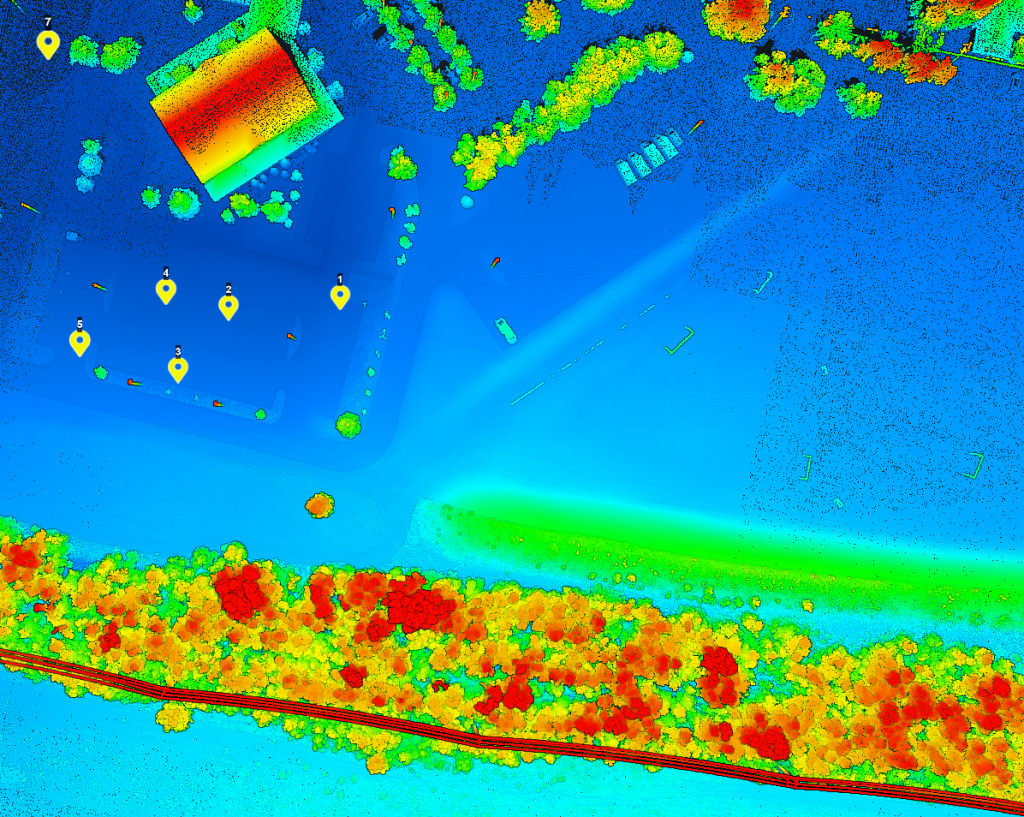
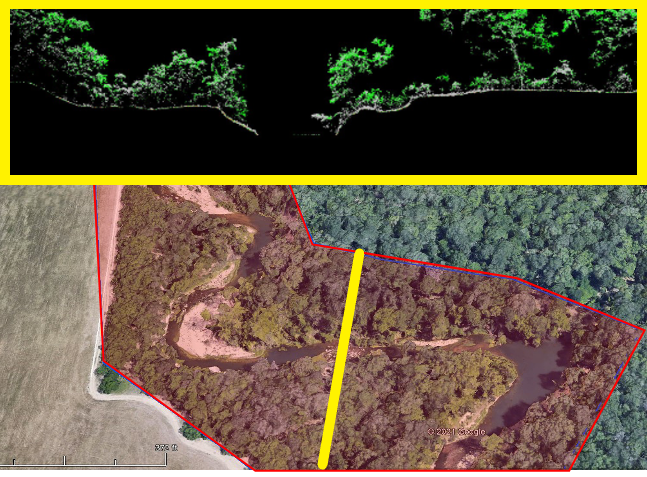
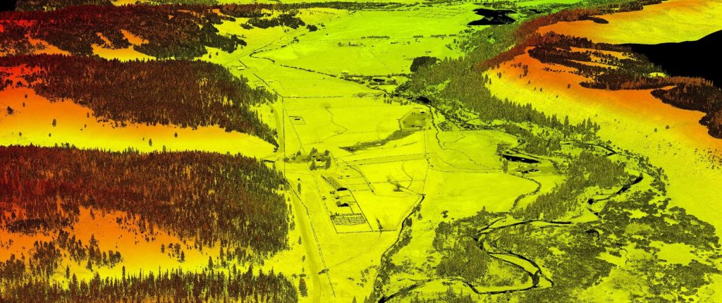
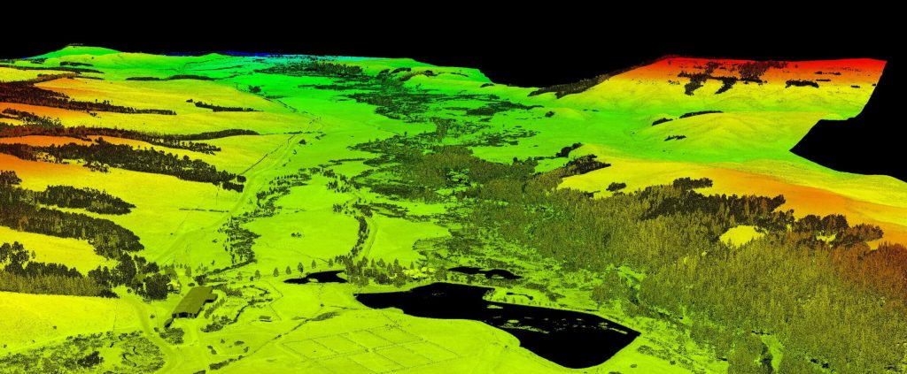
Pape-Dawson mapped two miles of riverbank for a client interested primarily in the features at the top of the bank on one side. Their team mapped the site within 45 minutes leveraging the UAV-based RANGER-LITE system. They collected the river bank of interest as well as the other bank, and even captured the exposed river bed features. Their team delivered the necessary data deliverables in two days, while simultaneously working on other projects.
Results
Heavily vegetated sites used to take Pape-Dawson’s surveyors several days to cut line through vegetation in preparation for data collection. Now, the team let’s the RANGER-LITE do the heavy lifting, mapping large scale and complex vegetated sites in under an hour. Accurate existing conditions surveys are critical, especially as it pertains to mass grading or dirt quantity calculations projects. They now capitalize on the enhanced resolution and accuracy provided by the RANGER’s LiDAR data for faster and more accurate quantity takeoffs, saving their team time and saving their customers money.
PARAMETERS
Scope: 2 mile river corridor
Acquisition Time: 45 minutes
Processing Time: 2 days

Quick Turnaround Time, Massive Data Collection, Tight Weather Window
Use Case: Implementing LiDAR in Pipeline Surveys Expands Project Scope Capabilities for MSI
Company: Measurement Sciences Inc.
Challenge
MSI, Inc. leverages lidar technology in the oil and gas industry by expanding their project scopes and increasing the number of completed surveys within the short fair-weather window between snowmelt to snowfall.
They implement lidar in pipeline surveys to be able to show a grander scope of the river crossing and banks. LiDAR enables their team to produce a much more detailed pipeline profile than traditional methods (i.e. taking gridded shots every 5 meters with GNSS), and offers expanded client deliverable offerings.
Solution
MSI, Inc. leverages lidar technology in the oil and gas industry by expanding their project scopes and increasing the number of completed surveys within the short fair-weather window between snowmelt to snowfall.
They implement LiDAR in pipeline surveys to be able to show a grander scope of the river crossing and banks. LiDAR enables their team to produce a much more detailed pipeline profile than traditional methods (i.e. taking gridded shots every 5 meters with GNSS), and offers expanded client deliverable offerings.
Application
MSI, Inc. leverages LiDAR technology in the oil and gas industry by expanding their project scopes and increasing the number of completed surveys within the short fair-weather window between snowmelt to snowfall.
They implement lidar in pipeline surveys to be able to show a grander scope of the river crossing and banks. LiDAR enables their team to produce a much more detailed pipeline profile than traditional methods (i.e. taking gridded shots every 5 meters with GNSS), and offers expanded client deliverable offerings.
Results
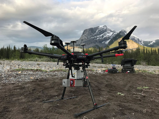
MSI, Inc. owns and operates three Phoenix LiDAR systems: the MiniRANGER-1, RANGER-LR, and RANGER-XL. Their best collection windows are early spring and late fall, so they try to group as many sites together as possible to map consecutively during two sizeable RANGER-XL helicopter campaigns each year. They deploy the UAS-based miniRANGER to supplement sites between those two collection windows. This keeps the cost of helicopter operations down and still enables MSI to collect sites on demand, if needed, rather than waiting for the two seasonal windows. The decision process for which Phoenix system to deploy varies site by site – depending on time of year, project scope, and strictness of deliverable timelines.
High Point Density, High Accuracy, High Measurement Range
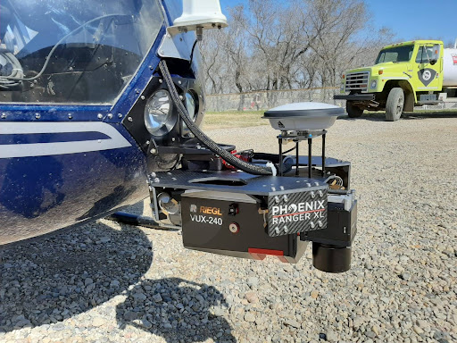
Use Case: Mapping the Rocky Mountain Foothills with the Helicopter-Mounted RANGER Series
Company: SkySkopes
Challenge
SkySkopes is a professional service provider with a highly qualified operations and geospatial team. They operate a wide variety of advanced sensors and aircraft for transmission and distribution line inspections, oil and gas applications, and many other innovative use cases that focus on adding value.
The challenge was finding a solution that could be adaptable to unmanned aircraft, rotorcraft, and fixed wing platforms.
“SkySkopes utilizes unmanned aircraft, rotorcraft, fixed wing, and mobile platforms. One of the benefits of Phoenix LiDAR systems is the ability to use the same sensor on multiple platforms.”
Eric Goetsch, VP of Helicopter Operations, R&D
Solution
One of the benefits of Phoenix LiDAR systems is the ability to use the same sensor on multiple platforms. With the purchase of the RANGER-XL system, SkySkopes could bid on fixed wing, rotorcraft, and UAV based projects.
Benefits
- Ability to fly high and fast, without sacrificing point density
- Efficiently collects high precision, high accuracy data
- Adaptable to a wide variety of vehicle platforms
- Turn Key operation
“We have been able to bid on and win numerous projects just based off of our RANGER-XL LiDAR system. Being able to utilize that system in such a variety of project types and industries allows for a faster return on investment.”
Eric Goetsch – VP of Helicopter Operations, R&D
Acquisition
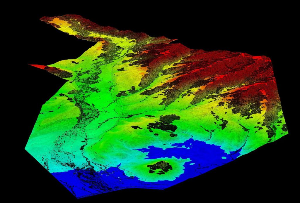
SkySkopes completed a wide area mapping pre-construction survey in the foothills of the Rocky Mountains with a scope of 12,000 acres. Taking the size of the project into consideration, as well as the complex and challenging mountainous terrain, their team selected a Bell 407 helicopter with a RANGER-XL. The RANGER-XL’s long ranging capability allowed the team to safely and efficiently collect data at 1,200ft above the ground, flying at a ground speed of 60 knots, all while meeting and exceeding the project’s point density requirement of 30 points per square meter.
Results
The SkySkopes team has reliably bid on and won numerous projects based off of the capabilities of their RANGER-XL LiDAR system. Utilizing the RANGER-XL solution in a variety of project types and industries allowed for a faster return on investment. Leveraging the ranging capabilities of the RANGER-XL combined with the endurance of the Bell 407, enables their team to safely, efficiently, and reliably map large areas while penetrating dense foliage.
PARAMETERS
Site: 2,000-acre pre-construction survey in the foothills of the Rocky Mountains
Solution: RANGER XL + Bell 407 Helicopter
AGL: 1200ft
Point Density: 30 points per square meter
Time: 5 hours
Explore the transformative role of LiDAR technology in urban development through EHRA’s use of the Mini-Ranger LiDAR system. This video highlights how EHRA, a leading engineering firm, utilizes drone LiDAR to revolutionize urban planning and project management.
The Mini-Ranger system, acclaimed for its precision in terrain and vegetation data collection, enables efficient project execution and detailed site analysis, ensuring cost-effective management and enhanced flood prevention strategies.
Join Aaron Kelsey, EHRA’s Senior Survey CAD Tech and Drone Program Manager, as he discusses the system’s capacity to survey extensive areas swiftly, reducing both time and labor costs significantly.
The reliability and high-quality data collection of the Mini-Ranger system have proven essential in multiple large-scale projects, supported by the excellent customer service from Phoenix LiDAR.
This session also covers the evolution from traditional survey methods to advanced LiDAR technology, underscoring its accuracy and the objective data crucial for drainage studies and boundary surveys. Celebrate Phoenix LiDAR’s decade of innovation and discover how their technology is pivotal in advancing urban engineering practices.
Discover the revolutionary impact of LiDAR technology in urban development with EHRA’s utilization of the Mini-Ranger LiDAR system. In this video, learn how EHRA, a leading engineering firm, leverages drone LiDAR for advanced urban planning and project management.
The Mini-Ranger system is celebrated for its precision in terrain and vegetation mapping, facilitating rapid and accurate data collection that drives efficient, cost-effective project outcomes.
Join Aaron Kelsey, EHRA’s Senior Survey CAD Tech and Drone Program Manager, as he discusses the system’s transformative effects on large-scale surveying—reducing both time and labor costs significantly. He also highlights its crucial role in flood prevention by providing detailed elevation data for effective drainage and water flow management.
The video also explores the evolution of surveying from traditional methods to cutting-edge GPS and LiDAR technologies, enhancing the reliability of data collection. With Phoenix LiDAR’s support, EHRA continues to push boundaries in urban engineering, making significant strides in project accuracy and efficiency.
Discover the groundbreaking impact of LIDAR technology in urban development with EHRA’s innovative use of the Mini-Ranger LIDAR system. In this insightful video, we delve into how EHRA, a leading engineering firm, leverages the power of Drone LIDAR and the MiniRanger system to revolutionize urban planning and project management.
In this informative video, Angela Livingston from Pape-Dawson Engineers, a leading firm in civil engineering and LiDAR services, shares her extensive experience and insights. Pape-Dawson Engineers has been around for over 50 years, expanding their operations across various locations in Texas and Florida. Angela, with a strong background in photogrammetry, LiDAR, and GIS, explains how the company has integrated LiDAR technology into their workflows to enhance efficiency and accuracy in land development projects. The company now utilizes multiple UAVs and LiDAR scanners, including the Phoenix Recon XP, Ranger VUX, and Ranger Ultra, to cater to diverse project needs.
Angela dives into the decision-making process behind choosing specific LiDAR systems based on factors such as vegetation, site size, and project requirements. She explains the strategic use of both drones and helicopters for LiDAR data acquisition, depending on the project’s scope and environmental conditions. This flexibility allows Pape-Dawson to efficiently handle larger projects, such as wastewater treatment plant expansions, and significantly reduce time and costs compared to traditional terrestrial scanning methods. Angela emphasizes the importance of selecting the right tool for the job to achieve the best results.
The video also covers the crucial aspect of standardized workflows and data processing techniques that Pape-Dawson employs. Angela highlights how having a well-defined process ensures high-quality and accurate deliverables for engineering projects. She explains their method of using Phoenix’s Spatial Explorer and Inertial Explorer for navigation processing, followed by Terra Solid and MicroStation for point cloud fusion and feature extraction. This meticulous approach allows Pape-Dawson to maintain consistency and reliability in their data outputs, which is essential for supporting their engineers’ work.
Towards the end of the video, Angela expresses her appreciation for the support and collaboration with Phoenix LiDAR Systems, noting how their responsiveness to feedback has led to hardware and software improvements. She encourages viewers to reach out to her via email for advice on project collection and sensor selection. Angela’s expertise and willingness to share her experiences provide a valuable resource for anyone looking to enhance their engineering projects with advanced LiDAR technology. For those interested, Angela can be contacted through Pape-Dawson’s website or directly via email.