
Resource Type
Industry
Product Group
We are excited to announce the opening of our new headquarters based in Austin, Texas! Our new facility offers numerous benefits to advance our operations and meet our customers’ needs:
• More than double the size of our Los Angeles facility
• Spacious conference rooms to accommodate multiple concurrent customer training sessions
• Close proximity to field sites for pilot and acquisition training
• Accommodations for system testing and calibration
• 30 minutes from the Austin-Bergstrom International Airport
• Less than 10 minutes from the Domain, a trendy Austin shopping center and social hotspot
As of Friday, June 26, 2020, all of our Los Angeles operations will be permanently relocated to our new facility located at:
2113 Wells Branch Parkway
Building 1, Suite #4000
Austin, TX 78728
We will not be able to receive mail or other shipments at 10131 National Blvd, Los Angeles, CA 90034 after June 26th. Please let us know if you have any questions.
Sincerely,
The Phoenix LiDAR Team
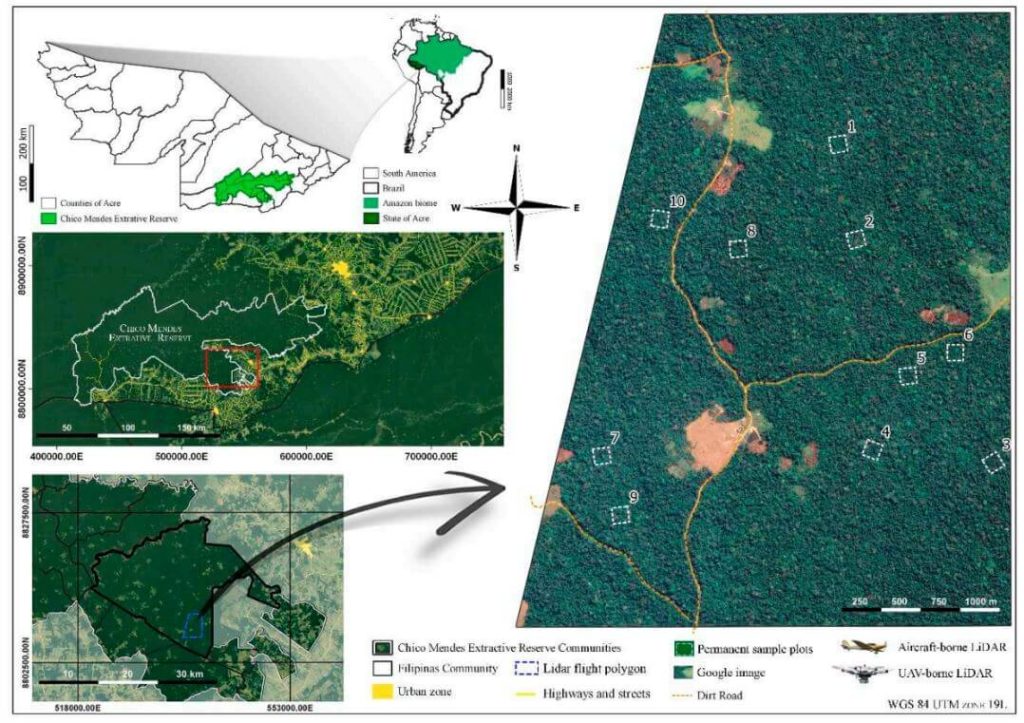
This whitepaper explores the challenges of obtaining high-quality forest structure information in tropical forests, particularly those in difficult-to-access areas. Traditional field-based approaches are often costly and time-consuming, prompting the use of LiDAR technology for efficient and comprehensive structural parameter estimates.
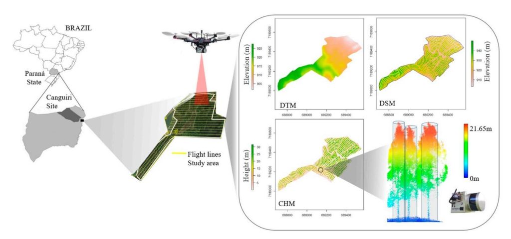
The study compares aboveground biomass (AGB) estimations and products from aircraft-borne LiDAR data collected in 2015 with data from the UAV-borne GatorEye Unmanned Flying Laboratory in 2017 across ten forest inventory plots in the Chico Mendes Extractive Reserve in Acre, southwestern Brazilian Amazon.
Findings indicate that both platforms produce comparable LiDAR products, with the GatorEye system demonstrating higher point density due to its lower and slower flight and increased returns per second. Despite these differences, ground point density remained similar between the systems.
Both sensors yielded analogous results for digital elevation models and estimated AGB. This study validates the effectiveness of UAV-borne LiDAR sensors in accurately quantifying AGB in dense tropical forests and highlights the potential for detailed analyses of crown structure and leaf area density distribution using dense point clouds from UAV systems.
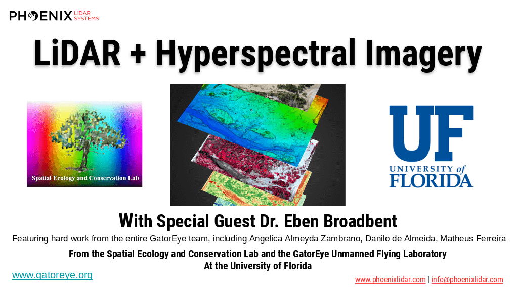
The high dimensionality of data generated by Unmanned Aerial Vehicle(UAV)-Lidar makes it difficult to use classical statistical techniques to design accurate predictive models from these data for conducting forest inventories. Machine learning techniques have the potential to solve this problem of modeling forest attributes from remotely sensed data. This work tests four different machine learning approaches – namely Support Vector Regression, Random Forest, Artificial Neural Networks, and Extreme Gradient Boosting – on high-density GatorEye UAV-Lidar point clouds for indirect estimation of individual tree dendrometric metrics (field-derived) such as diameter at breast height, total height, and timber volume.

Mohawk College recently partnered with the Niagara Parks Commission on a critical project, utilizing their Phoenix LiDAR Scout 32 system to achieve two key objectives. First, they generated a precision high-resolution 3D model of the historic Toronto Power Generation Station. This data is instrumental for the rehabilitation efforts to preserve this architecturally significant structure.
Second, they accurately scanned and geo-located a century-old barge that had been lodged above Niagara Falls since 1918. Dislodged by a powerful storm, the barge moved 150 meters downstream, closer to Horseshoe Falls. Niagara Parks Officials are closely monitoring its potential movement.
UAV LiDAR technology enabled the team to geo-locate the barge with centimeter-level precision and create a detailed cultural heritage preservation model of the power station. This project underscores the critical role of advanced LiDAR technology in historical preservation and environmental monitoring.
Check out their fine work and some incredible footage from the Niagara Falls project here!

As most of you are undoubtedly aware, COVID-19 pandemic concerns have forced many businesses including all casinos along the Las Vegas strip to temporarily shut their doors. Since everyone is now advised to stay away from this area, the Phoenix LiDAR team would like to give you the next best thing – a virtual tour! Check out a beautifully colorized LiDAR scan of the Las Vegas strip collected with our Phoenix Ranger LR solution and multi-camera array by manned helicopter.
We have also included another data set to share what is possible when you utilize LiDAR data as a baseline for ground and flat surfaces, to enhance dense image matching within a third party product like Context Capture to create a robust mesh model.
There were no interiors scanned this time around. So, sadly there will be no table games or showgirls on this particular tour. However, please enjoy this impressive data set, and experience the majesty of the Vegas strip safely from your home! Happy touring and stay safe out there!
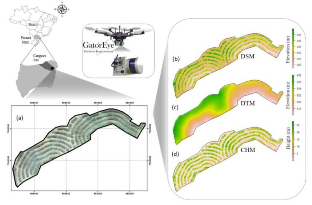
This whitepaper examines the potential of UAV-borne LiDAR technology, specifically the GatorEye system, for measuring essential forest parameters such as diameter at breast height (DBH) and total tree height. Traditionally, these parameters are measured manually using level gauges and hypsometers in sample plots, a process that is laborious, expensive, and spatially limited. Terrestrial laser scanning (TLS) has been used for remote DBH measurement, offering high-density point clouds for accurate inventory but facing spatial limitations due to manual deployment and field access challenges.
The study demonstrates the effectiveness of UAV-LiDAR in providing higher density point cloud data compared to aircraft-borne systems. Focusing on an integrated crop-livestock-forest system with Eucalyptus benthamii plantations, 63 trees were georeferenced and measured in the field. Algorithms typically used for TLS were applied to the UAV-LiDAR point cloud for automatic individual tree detection and measurement.
The UAV-LiDAR-derived DBH and total height showed strong correlations with field measurements, with correlation coefficients of 0.77 and 0.91, and RMSEs of 11.3% and 7.9%, respectively. This study underscores the potential of UAV-LiDAR systems to efficiently measure forest plantations on a broad scale, reducing field effort and enhancing forest management decision-making. Further exploration in diverse tree plantations and forest environments is recommended.
We’re excited to announce the release of LiDARMill v2! LiDARMill v2 takes automated post-processing to the next level. In our recent webinar, we covered some of the new improvements and features including:
- Imagery Processing in LiDARMill
- Ground Control Reporting and Adjustments
- Robust Coordinate System Handling
- A Workflow Overview and Demonstration
- Multi-Mission Processing Support
- Advanced Point Cloud Filtering Options
- RGB Thermal & Fusion
- Accuracy Reporting
- Automated LiDAR and Camera Calibration Options
- Near-Real Time (NRT) Reference Station Positioning for Projects Requiring Less Than 24 Hour Turn-around Time
- Trajectory Post-Processing Without Reference Stations
If you have any questions or would like to learn more about LiDARMill v2, please don’t hesitate to get in touch. We’d be happy to help!
We’re happy to announce the release of SpatialSuite 5.0! Make sure to check out our webinar led by Post Processing Manager, Conrad Conterno, to learn about the many, powerful new tools and features. In this webinar we cover:
- The .cloud format
- LiDARSnap Plugin
- CameraSnap Plugin
- Classification/Point Filtering Plugin
- Exporting Vector and Raster Products
- System Visualization Tools
- Other New Features (i.e. RXP to SDCX converter, LAS Viewer, and more.)