RANGER-Flex
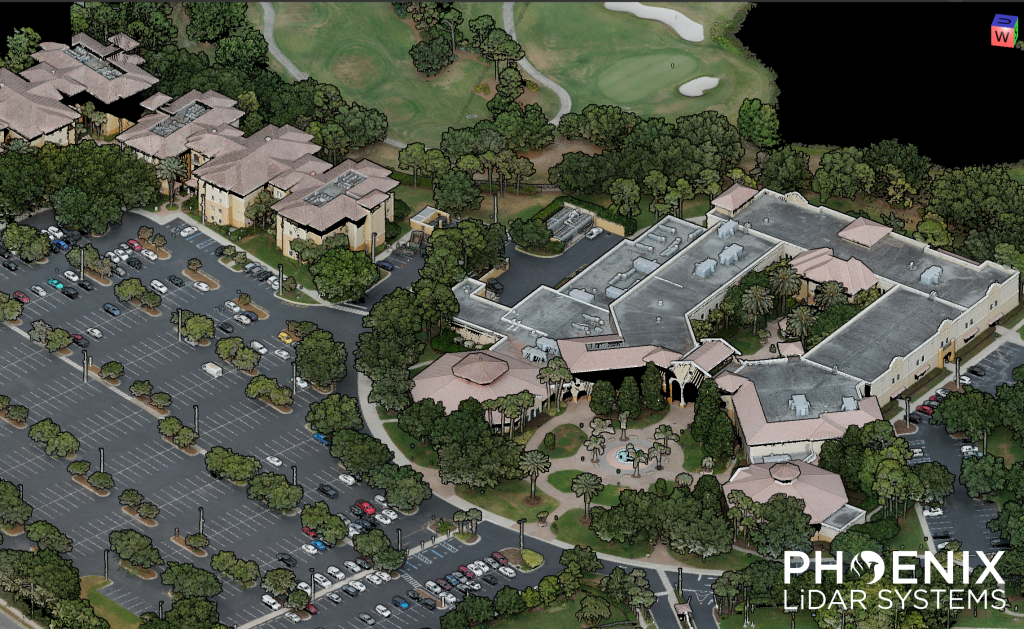
Check out our RANGER-Flex 𝗠𝗼𝗯𝗶𝗹𝗲 + 𝗔𝗲𝗿𝗶𝗮𝗹 𝗱𝗮𝘁𝗮 𝘀𝗲𝘁 of the University of Central Florida – Rosen College of Hospitality Management, recorded during the 2025 TopoDOT User Conference.
This data set features mobile and aerial scans by the RANGER-Flex, which were matched together using 𝗟𝗶𝗗𝗔𝗥𝗦𝗻𝗮𝗽. First, the site was flown using a single 𝗥𝗔𝗡𝗚𝗘𝗥-𝗙𝗹𝗲𝘅 LiDAR system mounted to a Harris Aerial 𝗛𝟲𝗘. Then, this same aerial LiDAR system was mounted inside the 𝗥𝗙𝗠𝟮 𝗺𝗼𝗯𝗶𝗹𝗲 𝘀𝘆𝘀𝘁𝗲𝗺, which enables dual-head mobile LiDAR collection.
Once the mobile data set was collected, the scans were matched together automatically using 𝗟𝗶𝗗𝗔𝗥𝗦𝗻𝗮𝗽’𝘀 𝗖𝗼𝗻𝘁𝗿𝗼𝗹 𝗖𝗹𝗼𝘂𝗱 functionality. Both scans were then colorized using the 𝟲𝟭 𝗠𝗣 𝗥𝟲 aerial camera.
Full Dataset available for download. Contact our team at sales@phoenixlidar.com for a link to download.
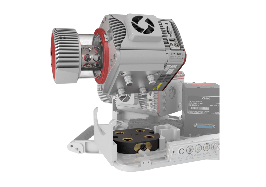
Modularity is a key feature of the RANGER-FLEX laser mapping product line.
These systems can be quickly reconfigured, with sensors added and/or removed, to allow for optimized utilization on a variety of vehicle types. Modularity also presents a challenge: How can a system calibration, which is a cornerstone of data accuracy, be preserved if laser scanners and cameras are routinely separated from each other and from the navigation system? The RANGER-FLEX has been engineered to specifically address this, and a series of datasets were collected to test the stability of its calibration.
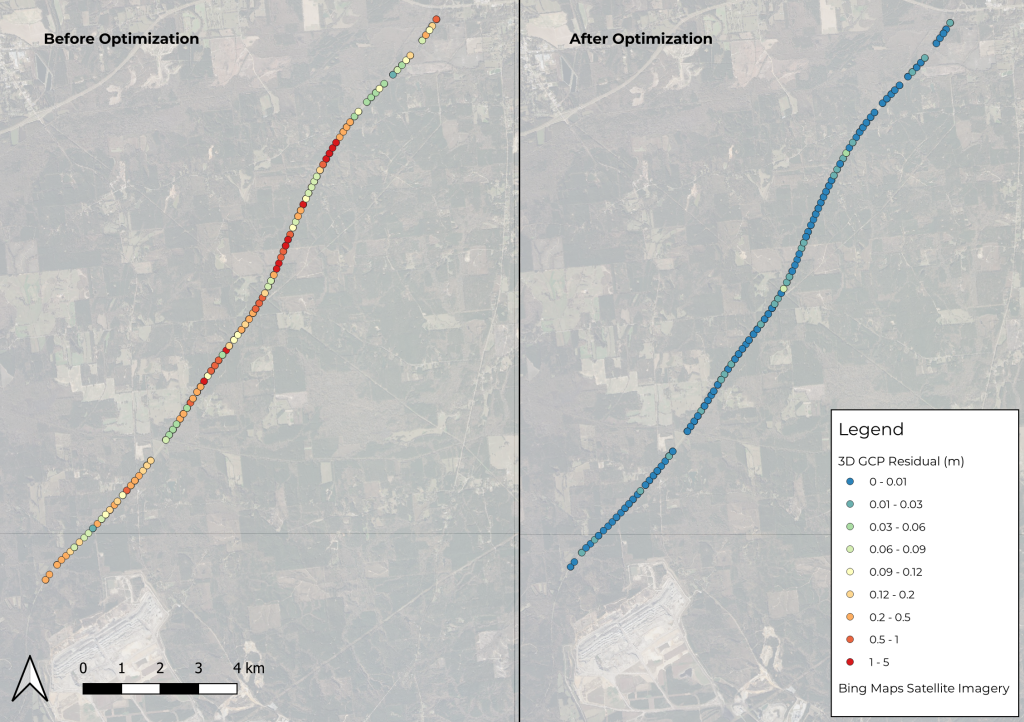
Phoenix LiDAR’s SpatialExplorer’s LiDARSnap strip alignment tool was tested using a challenging mobile LiDAR dataset collected along a rural state road, Natchez Trace Parkway, near Mathiston, Mississippi. Approximately 17.5 km of the parkway was mapped using the RANGER Flex dual-head mobile LiDAR mapping system.
Of the total mapped area, nearly 85% was covered by a dense tree canopy, which posed a significant accuracy challenge due to the limited availability of GNSS signals. LiDARSnap was utilized not only to calibrate the relative accuracy of the two passes but also to georeference the scan in relation to leveled control.
This paper discusses the processing workflow, results, and capabilities of LiDARSnap in challenging, GNSS-denied environments.
Speed: 20-30 mph
Point density: >2000 points/m²
AGL: Ground level
Acquisition time: 1.5 hrs
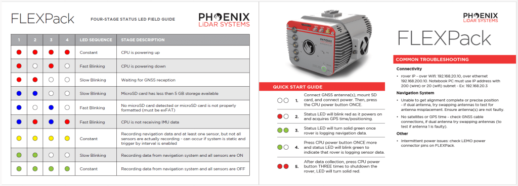
Ensure your LiDAR system is ready for field operations with our comprehensive RANGER Flex LED Quick Start Guide. Download now to streamline setup and maximize performance.